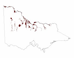
4.1 Modern floodplains
4. Northern Riverine Plain (RP)
4.1.1 - Meander belt below plain level, sometimes source-bordering dunes (Mooroopna, Wangaratta)
4.1.2 - Areas of inundation away from modern channels (Gunbower, Forest, Dingee swamps, Loddon fan, Carag Carag)
4.1.3 - Lakes and basins with lunettes (Kow Swamp, Lake Cooper, Kanyapella depression)
| The modern flood plains comprise today’s active rivers and flood plains as well as inundated swamps and associated with flood events. The alluvial sediments comprising the modern flood plains are known geologically as the Coonambidgal Formation and date from end of the last glacial period about 15 000 years ago to the present. The major rivers, the Murray, Goulburn and Campaspe, have well defined flood plains with inset terraces and extensive flood-plain meander belts with scrolls and oxbow lakes (see 4.1.1). While the Loddon and Wimmera rivers have well defined channels, their flood plains are not as extensive. Also included in the modern flood plains are occasionally inundated areas away from the modern rivers such as the Gunbower Forest, the swamps near Dingee, the Carag Carag swamp near Stanhope and an area known as the Loddon Fan (4.1.2). Lakes, swamps and depressions with crescent shaped rises on their eastern margin are also found across the riverine plain (4.1.3). These rises are called lunettes and were formed by the deflation of lake floor sediments during dry periods. Examples of these are Lake Cooper, Kow Swamp and the Kanyapella depression near Echuca. |  |
Related information on VRO
- A Study of the Land in North-western Victoria (J N Rowan and R G Downes 1963)
- Land Inventory of the Loddon River Catchment - a reconnaissance survey (N Schoknecht 1988)
- A Study of the Land in the Campaspe River Catchment (M. S. Lorimer and N. R. Schoknecht 1987)
- A Study of the Land in the Catchment of the Avoca River (M. S. Lorimer and J. N. Rowan 1982)
- A Study of the Land in the Catchment of the Broken River (Allen S. Rundle and R. K. Rowe 1974)
- A Study of the Land in the Grampians Area (Sibley 1967)
- Land Inventory of the Wimmera Systems and Rocklands Water Supply Catchments - A Reconnaissance Survey (L.A. White, P. J. Kelynack, F. Gigliotti, P. D. Cook 1985)
- A Study of the Land in the catchments of the upper Ovens and King Rivers - TC-16 (R. K. Rowe 1984)


