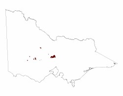
2.1.3 Ridges, escarpments, mountains on granitic Palaeozoic rocks (Mt. Cole, Langi Ghiran, Mt. Beckworth, Mt. Alexander)
2. Western Uplands (WU)
2.1 Dissected Uplands
| A diverse range of landforms are associated with the granite plutons which have been unroofed by erosion during the past 300 million years. The most common landscapes of the Palaeozoic granites are generally very subdued low hills and ridges of deeply weathered rock, such as those around Yendon and Lismore. In places, the deep weathering has produced thick (~40 m) kaolin clays, which are commercially mined at Pittong and Lal Lal. Based on oxygen isotope dates from these locations, the weathering is generally regarded as Neogene in age (Bird & Chivas 2002). However, in other locations the granites are exposed as tors (such as in the You Yangs), and as grus (such as on the flanks of Flagstaff Hill, Pittong). In some areas the metamorphic aureoles around the granites are resistant to weathering and form prominent ridges (such as the range south of Mount Bute at Pittong). The granites generally have developed sandy soils, with profiles varying from uniform or weakly gradational sands to strongly texture contrast ferruginised (‘buckshot’ or iron pan) soils. |  |
Ridges, escarpments and mountains of granitic origin can be found within the highest reaches of the Wimmera River and Mount Cole Creek catchments. These granitic plutons are scattered throughout the Midlands and form prominent hills and mountains that rise above their surrounding metamorphic aureoles and other areas of country rock (Joyce et al 2003).
The positive relief plutons such as Langi Ghiran (922 m), formerly known as Larne Gerin (Hills 1975), Ben Nevis (879 m) and the western Black Range (559 m) form prominent hills and mountains that rise above surrounding metamorphic aureoles and alluvial drainage systems. Tors and boulders of granite and larger granite outcrops represent whalebacks on their flanks (Cayley & MacDonald 1995). The slabby cliffs that rise above rock overhangs (whaleback) of Ben Nevis are the largest developed in Victoria.
Significant plateau remnants are preserved on the Mount Buangor Range with very minor segments preserved on Langi Ghiran. The plateaus have low gradients with moderate to gently inclined slopes with streams that drain these surfaces. Margins of the plateaus are steep to very steep with radial drainage away from these plutons.
Granitic landscapes within the Wimmera CMA region comprise granite plutons belonging to three suites (Mount Cole, Glenlogie and Ararat) that approximately intruded 390 million years ago (White & Chappell 1983) as part of the Lachlan Fold Belt plutonism events. These granitic masses that have been stripped of ancient palaeosurface materials have left pronounced topographic features (plateaus) on steep to precipitous slopes. Plateau remnants, considered to be early Mesozoic in age (Hills 1940; King 1959), are the oldest surviving geomorphological features of the Wimmera CMA region.
The Langi Ghrian Granite, Ben Nevis Granite, Mount Cole Adamellite all form part of the Mount Cole suite within the Stawell Province of the Whitelaw Terrane. Regolith is relatively shallow to non-existent on steeper slopes with deeper profiles occupying plateau cappings. The Black Ranges are derived from the Stawell Granite where little regolith exists and is dominated by rocky outcrop.
The granites generally have developed sandy soils, with profiles varying from uniform or weakly gradational sands (Kandosols) to strongly texture contrast ferruginised (‘buckshot’ or iron pan) soils (Chromosols and Kurosols). The yellow texture contrast soils are strongly acidic at surface, becoming slightly acidic or neutral at depth. Weakly structured surfaces overlie a massive horizon with variable amounts of coarse quartz fragments. Subsoils are medium to heavy clays often with conspicuous mottling. Total soil depth is variable depending upon differential weathering but generally increase with decrease in topographic position.
Vegetation is dominated on the Mount Cole granitic suite by Grassy Dry Forest. Other vegetation communities present include Herb-rich Foothill Forest, Hills Herb-rich Woodland, Grassy Woodland and Alluvial Terraces Herb-rich Woodland/Plains Grassy Woodland Complex. The Black Range has a similar variety of remnant vegetation communities, however it is more exposed to prevailing winds from the north, south and west. Riparian Scrub, Shallow Sands Woodland, Creekline Grassy Woodland, and Heathy Woodland are variants.
Groundwater migrates through aquifers comprising either abundant colluvium found on slopes or underlying weathered and fractured/jointed bedrock. Shallow perched groundwater through lateral flow migrates down slope and discharges at break of slope or feeds into basal aquifers that underlie adjacent valleys (Wimmera Regional Salinity Action Plan 2005 (external link) To view the information PDF requires the use of a PDF reader. This can be installed for free from the Adobe website (external link)).
The eroding granitic slopes are extremely vulnerable to extreme rainfall events in the form of sheet and rill erosion. Landslides and mud flows can eventuate where extreme rainfall events are coupled with land clearance and steep slopes. Landslips and mudflows occur where saturated soils fail.


