Victorian Dairy Soils - Sodosols
Back to: Victorian Dairy Soil
Sodosols (Australian Soil Classification) have a strong texture contrast between sandy to clay loamy surface (A) horizons and dense and coarsely structured clayey subsoil (B) horizons that are sodic (i.e. exchangeable sodium percentage is 6 or greater) and not strongly acid (i.e. pH 5.5 or greater).
Sodosols can be separated on the basis of the colour of the upper 20 cm of the subsoil into Red, Brown, Yellow, Grey and Black Groups. Further separations within these Suborders are made largely on the basis of key chemical characteristics (e.g. degree of sodicity).
Distribution
Northern Victoria
| Red Sodosols (previously referred to as ‘red-brown earths’) occur extensively on the older alluvial plains in northern Victoria. Older alluvial plains occupy most of the Riverine Plain, and the soils are mainly red Sodosols, often with calcium carbonate (‘lime) in the subsoil. In some areas there is a textural sequence from soils with a higher proportion of sand on prior stream levees to more clay rich soils on the floodplains. The lighter surface soils generally have higher productivity, both under dryland and irrigated farming. The heavier soils are more affected by hard-setting surfaces and lower hydraulic conductivity. | 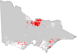 |
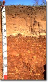 Red Sodosol with deep, sandy surface horizons overlaying sodic subsoil | 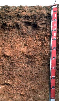 More typical red Sodosol with shallow (10 cm) fine sandy clay loam surface overlying sodic clay subsoil |
Links to example soil profiles of Sodosols in the Northern Victoria dairy region are provided below:
Red Sodosol near Tatura
| Gippsland Yellow and Brown Sodosols are most common in the eastern (lower rainfall zone) part of the region, generally to the east of Traralgon. They occur on Neogene (Tertiary) plains and rises as well as on the extensive alluvial plains and river terraces deposited during the Pleistocene Period - north and south of the LaTrobe River and around Yarram. The soils on the oldest alluvial plains are mostly Brown and Yellow Sodosols. Links to some example soil profiles of Sodosols in the West Gippsland dairy region are provided below: Yellow Sodosol near Maffra Brown Sodosol near Heyfield | 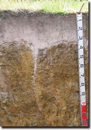 Brown Sodosol in far West Gippsland with distinct columnar structure in subsoil and sandy surface horizons 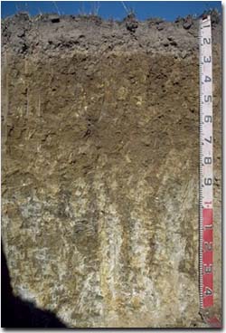 Brown Sodosol near Maffra with fine sandy loam surface horizons overlying dense sodic clay subsoil |
| South West Black, Brown and Grey Sodosols are common on basalt plains and rises throughout much of the eastern part of the region region and also on sedimentary plains and rises south of the Princes Highway in lower rainfall areas. The subsoils of Sodosols in the region also often display a strong shrinking and swelling characteristic i.e. vertic, and the subsurface horizons can be ferric i.e. contain significant amounts of ferruginous nodules (buckshot). Links to some example soil profiles of Sodosols in the South West dairy region are provided below: Grey Sodosol near Camperdown Brown Sodosol near Allansford Black Sodosol at Glenormiston | 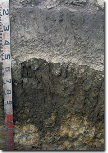 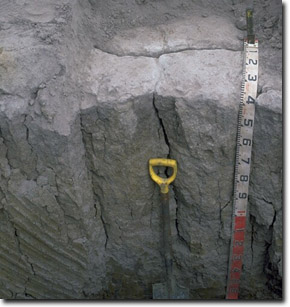 Examples of dense and coarsely structured subsoils in South West Victoria. Coarse columnar structure is evident in the subsoil of the image to the right and prismatic structure in the subsoil to the left. Both profiles display distinctive bleached subsurface horizon overlying the subsoil, often containing significant ‘buckshot’. |
Management Considerations
Surface horizons are usually hardsetting and upon wetting and drying the surface soil sets hard and will be difficult to work and may become “powdery” when worked in a dry condition, risking loss by wind. Cultivation of such soils when wet may result in surface sealing upon drying. Tillage should be minimised and stubble retention/pasture rotations practised.
Often surface and/or subsurface horizons can disperse strongly after remoulding and pugging . This indicates that they may disperse if excessively cultivated or overstocked when wet (particularly when the soil is wetter than the ‘plastic limit’) which can degrade soil structure and increase compaction. Gypsum can be beneficial in these situations.
The coarsely structured subsoil is sodic and usually disperses strongly in water. This results in restricted root, water and gas movement through the profile. The presence of bleached subsurface (A2) horizon above the sodic subsoil indicates that water movement is restricted and that waterlogging can occur in wet seasons. Bleached subsurface horizons often become “spewy” and tractor bogging potential can be high in winter. Lighter-textured (i.e. sandy) surface soils, where present, allow plants to respond to lower rainfall events. Surface soil structure is often weak and pugging can be an issue in winter and spring. Bleached subsurface horizons often become “spewy” and tractor bogging potential can be high in winter.
It is common for Sodosols in northern Victoria (and some developed on basalts in the South West) to be slightly acid in the surface soil but become strongly alkaline with depth. The level of soluble salts (salinity) can also increase significantly in the deeper subsoil.


