Chromosols
Chromosols have a strong texture contrast between the loamy surface (A) horizons and the clayey upper subsoil (B2) horizon. The subsoil is also not strongly acid i.e. the pH is greater than 5.5 in water and is not sodic.
 North East Chromosols |
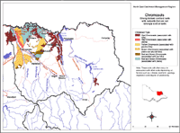
This broad-scale overview map of Chromosols in the North East region has been developed chiefly by Ken Rowe and is based on the Land Systems of Victoria (1:250 000). Other contributors have also assisted in updating the map in areas where they have specialist knowledge. The map shows areas where Chromosols are most likely to occur within the region and should only be used as a general indication of their distribution. Note that other soil types may also occur within these mapped areas (either dominantly or sub-dominantly) depending on factors such as climate, landform, geology, vegetation and degree of weathering. This map will continue to be updated as new information becomes available. Access the Soil and Land Survey Directory from this website to research more detailed information from various soil and land surveys that cover parts of this region. |
Chromosols are most common in the north-western quarter of the North East region. They occur on the broad plains to the north of Myrtleford and west of Wodonga, in the lower reaches of the Kiewa Valley and to a lesser extent in the Murray and Mitta Mitta valleys upstream of Lake Hume. The Red Chromosols appear to be slightly less-acid phases of the more widespread Red Kurosols in those valleys. The pattern of Chromosol distribution in North East Victoria seems to be related to the lower rainfall in that part of the region, relative to the distribution of other more acid soils such as Kurosols and acidic Dermosols.
The presence of extensive areas of calcareous clayey sediments of wind-blown origin is referred to as parna. Parna is found on the plains of the Riverina and Goulburn Valley to the north and west. It has been concluded that parna must also have been deposited over a much wider area, including the higher rainfall areas in North East Victoria. In these areas, the higher rainfall has resulted in greater leaching of calcium, sodium and magnesium from the soils, and the subsoil has increased in acidity. In areas of less rainfall, the degree of leaching is less and the soils retain higher proportions of the alkaline cations. Consequently, the pH is less acid.
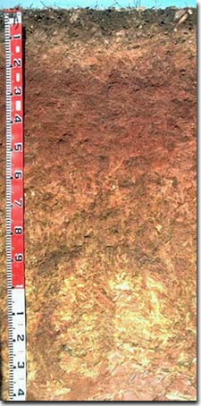
Red Chromosols Red Chromosols are usually found on the more freely draining landforms e.g. prior stream ridges and the older or slightly higher terraces. They can also occur in hilly areas e.g. Rutherglen area. These soils were previously referred to as red Duplex soils and red-brown earths when subsoils are more alkaline. Generalised Description A horizons: shallow, loamy A1 horizon, overlying paler (bleached) apedal A2 horizon, slightly acidic, ironstone concretions, 'buckshot' may occur at the boundary with the subsoil, clear to abrupt boundary change. B horizon: clay texture, strongly developed medium to coarse blocky structure, weakly acid to alkaline. |  A Red Chromosol on sedimentary rises near Rutherglen. |
These soils were previously known as yellow or brown Duplex soils. They tend to occur in less well drained situations than the Red Chromosols.
References
Rowe, R.K (1967). A Study of the Land in the Victorian Catchment of Lake Hume. Soil Conservation
Authority. Victoria. Technical Communication 5.
Rowe, R.K (1972). A Study of the Land in the Catchment of the Kiewa River. Soil Conservation Authority. Victoria.
Technical Communication 8.
Rowe, R.K (1984). A Study of the Land in the Catchments of the Upper Ovens and King Rivers. Soil
Conservation Authority. Victoria. Technical Communication 16.


