MP4
Location: Walpeup
Australian Soil Classification: Endohypersodic, Pedal, Hypercalcic CALCAROSOL
Northcote Factual Key: Dr2.13
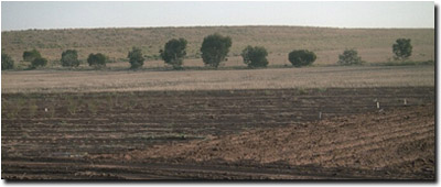
General Landscape Description: Open depression within a swale.
Site Description: Mallee Research Station lysimeter trial site. Completely cleared, pasture, cultivated as some stage in the past.
 MP4 Landscape |
Soil Profile Morphology:
Surface Soil
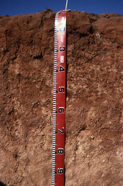
| A1 | 0-10 cm | Reddish brown (5YR4/4); sandy loam; massive; very firm consistence dry; contains a few (2-10%) calcareous nodules; slight effervescence; pH 6.8; clear and smooth change to: |  MP4 Profile |
Subsoil | |||
| B21 | 10-25 cm | Red (2.5YR4/8); light medium clay; moderate medium prismatic, structure; very firm consistence dry; moderate effervescence; pH 8.1; diffuse and wavy change to: | |
| B22 | 25-65 cm | Red (2.5YR4/8); light clay; moderate blocky structure; firm consistence dry; contains many (20-50%) soft calcareous segregations; very strong effervescence; pH 9.5; diffuse change to: | |
| B23 | 65- 200 cm | Olive (5Y5/8); light clay; strong consistence dry; contains a few (2-10%) calcareous nodules; very strong effervescence; pH 9.7: | |
| BC | 200+ cm | Heavy clay; coarse peds; pipe structures; contains a slight amount of manganese nodules; pH 8.7. | |
Soil Profile Characteristics:
pH | Salinity | |||
Surface (A1 horizon) | Slightly Acid | Low | Non-Sodic | None |
Subsoil (B21 horizon) | Moderately Alkaline | Very Low | Non-Sodic | None |
Deeper Subsoil (at 1 metre) | Extremely Alkaline | High | Extremely Sodic | Moderate |

| The surface horizon is slightly acid. The subsoil is moderately to strongly alkaline. | The salinity rating in the surface is low. The subsoil is also low becoming high with depth. | The surface and upper subsoil is non sodic. The deeper subsoil becomes extremely sodic | A sharp increase in clay occurs at the A/B horizon interface |
Chemical and Physical Analysis:
Horizon | Horizon Depth (cm) | pH (water) | pH (CaCl2) | EC dS/m | NaCl % | Exchangeable Cations | |||
Ca | Mg | K | Na | ||||||
meq/100g | |||||||||
A1 | 0-15 | 6.8 | 5.9 | 0.07 | 3.5 | 1.5 | 0.7 | <0.1 | |
A2 | 15-20 | 8.1 | 7.4 | 0.09 | 7.5 | 4.4 | 1.3 | 0.4 | |
A3 | 20-21 | 9.5 | 8.3 | 0.31 | <0.05 | 6.2 | 9.6 | 1.4 | 3.7 |
B21 | 21-35 | 9.7 | 8.4 | 0.95 | 0.13 | 2.6 | 6.4 | 1.2 | 7.6 |
B22 | 35-65 | 8.7 | 8.2 | 0.86 | 0.28 | 1.1 | 11.3 | 2.6 | 12.6 |
Horizon | Horizon Depth (cm) | Oxidisable Organic Carbon % | Total Nitrogen % | Field Capacity pF2.5 | Wilting Point pF4.2 | Coarse Sand (0.2-2.0 mm) % | Fine Sand (0.02-0.2 mm) % | Silt (0.002-0.02 mm) % | Clay (<0.002 mm) % |
A1 | 0-15 | 0.5 | 0.06 | 50 | 33 | 1 | 13 | 9.8 | 4.9 |
A2 | 15-20 | 40 | 26 | 3 | 25 | 16.8 | 10.9 | ||
A3 | 20-21 | 32.1 | 21.4 | ||||||
B21 | 21-35 | 28.3 | 19.9 | ||||||
B22 | 35-65 | 36.0 | 25.3 |
Profile Described By: Mark Imhof (March 1994).


