Salting on Dryland Farms in North-western Victoria
This report on: Salting on Dryland Farms in North-Western Victoria was prepared in 1971 by Jim Rowan of the former Soil Conservation Authority. The study utilised then recently available small-scale aerial photographs covering most of north-western Victoria to assess the distribution, extent and spread of saline surfaces in various topographic situations. This was done in 1966. In addition, field work was undertaken on several farms at sites affected to varying degrees by salting. The distribution of salts and moisture in landscapes was examined in relation to the nature of the soils and vegetation as a basis for consideration of the present and potential extent of deterioration of surface and subsoils, and to consider the effects of various practices of management on ecological stability.
To view the information PDF above requires the use of a PDF reader. This can be installed for free from the Adobe website (external link).
 | Summary (PDF 134KB) | V. | Discussion (PDF 114KB) | |
I. II. | Introduction (PDF 134KB) Environment (PDF 347KB)
Geomorphology Soils Salts in soils Origin of salts Native vegetation Land Use
Saltpans beside channels Saltpans on broad plains Saline surfaces on red clay plains |
The development of saltpans Undetected deterioration Prevention Soil Conservation | ||
VI. | Acknowledgements (PDF 113KB) | |||
VII | References (PDF 113KB) | |||
| vro | ||||
| Appendix I - Chemical Analysis of soils (PDF 144KB) | ||||
III. | Appendix II - Particle-size analysis (PDF 111KB) | |||
| Appendix III - Moisture in soils at various tensions (PDF 82KB) | ||||
| Appendix IV - Analytical Methods (PDF 108KB) | ||||
IV. | Fied Observations (PDF 939KB
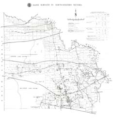
Dune - salted flat - dune transect. - Sites 3-10 Margin of a saltpan Flats with non-saline surfaces Large saltpan Partially-reclaimed saltpan Dune-flat transect with saltpan above the break in slope Moisture in dunes |  Saline surfaces in North-western Victoria (PDF - 1.6Mb) |


