
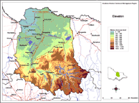
Elevation
The Goulburn Broken Region has a diverse topography with elevations ranging from 95 m above sea level along the Murray River in the north, to Mt. Buller summit being 1806 m above sea level in the mountainous south of the region. Much of the northern part of the catchment is of low relief.
|
This elevation map provides a broadscale overview of the relief across the region. The Digital Elevation Model (DEM) was derived from 1:25 000 topographic data, including contours, spot heights, hydrology (stream enforced) and shore boundaries using ANUDEM software. The interpolation of topographic data is to a 20 m x 20 m grid that has been resampled to a 100 m cell size for display on this website. |
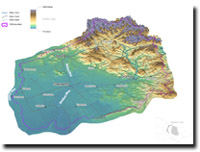
Goulburn Broken 3D Elevation Overview

© The State of Victoria, 1996 - .
This page was last updated on .