
WCSS3
Location: Longerenong
Australian Soil Classification: Epicalcareous-Endohypersodic, Self-Mulching, Grey VERTOSOL
Soil Map Unit: Kalkee Clay.
World Reference Base: VERTISOL
General Landscape Description: Very gently undulating plain.
Site Description: Flat, gilgai evident.
Native Vegetation: Sparse stands of remnant Buloke.
Geology: Quaternary alluvial and aeolian deposits.
Land Use: Long-term trial site for dryland cropping.
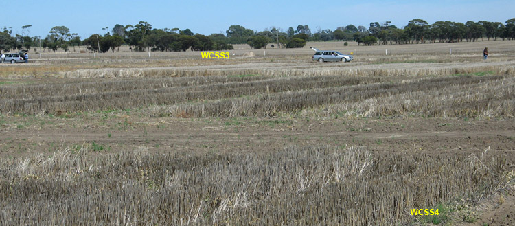
| WWPS3 Landscape |
Soil Profile Morphology:
Surface Soil
| A1 | 0-10 cm | Dark grey (10YR4/1); self mulching surface condition with slight compaction evident; light clay; weak consistence moist; pH 8.2; clear change to: | 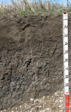 WWPS3 Profile |
| Subsoil | |||
| B21 | 10-35 cm | Dark greyish brown (10YR4/2); medium clay; moderate medium to fine sub-angular blocky structure; weak to firm consistence moist; pH 8.5; clear change to: | |
| B22 | 35-65 cm | Dark grey (10YR4/1); medium heavy clay; strong very coarse to coarse prismatic, parting to strong medium to fine sub-angular blocky structure; very firm consistence moist; slickensides in lower horizon; pH 9.0; gradual change to: | |
| B23k | 65-95 cm | Very dark grey (10YR3/1); medium clay; strong very coarse prismatic, parting to moderate to strong coarse to medium sub-angular blocky structure; very firm to strong consistence dry; soft and semi-hard very coarse (50 mm in size) calcareous segregations common (20%); pH 9.1; abrupt and tongued change to: | |
| B24k | 95-130 cm | Light brown (7.5YR6/4); medium heavy clay; moderate to strong coarse to medium blocky structure; very firm to strong consistence dry; many (40%) soft and semi-hard calcareous segregations; pH 9.2. |
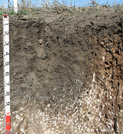
WWPS3 Profile variation
Soil Profile Characteristics:
| - | pH | Salinity | ||
Surface (A1 horizon) | Moderately Alkaline | Very low | Non-Sodic | None 1 |
Subsoil (B21 horizon) | Strongly Alkaline | Low | Non-Sodic | None 2 |
Deeper Subsoil (at 90-130 cm) | Very Strongly Alkaline | High | Strongly sodic | None |
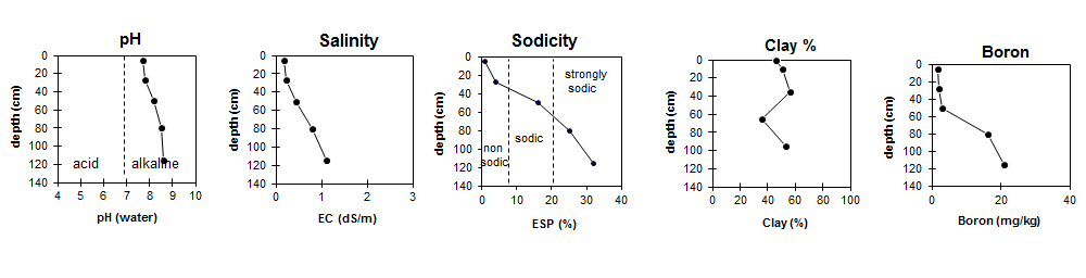
| The surface is moderately alkaline. The upper subsoil is strongly alkaline, becoming very strongly alkaline with depth. | The salinity rating in the surface is very low. The subsoil has a low salinity rating, becoming high with depth. | The surface is non-sodic. The upper subsoil is non-sodic, becoming strongly sodic with depth. |
| Boron levels are relatively low in the upper soil profile but become high below 50 cm depth. |
Chemical and Physical Analysis:
Horizon | Horizon Depth (cm) | pH water | pH CaCl2 | EC dS/m | Sodium Chloride l% | Organic Carbon % | Total Nitrogen % | Exchangeable Cations | Boron mg/kg | Field Capacity pF2.5 | Wilting Point pF4.2 | Coarse Sand (0.2 - 2.0 mm) | Fine Sand (0.02-0.2 mm) | Silt (0.002-0.02 mm) | Clay (<0.002 mm) | |||
Ca | Mg | K | Na | |||||||||||||||
meq/100g | ||||||||||||||||||
A1 | 0-10 | 8.2 | 7.7 | 0.17 | - | 1.2 | 0.11 | 31 | 4.9 | 3.1 | 0.42 | 1.7 | 42.9 | 19.7 | 9 | 20 | 17 | 46 |
B21 | 10-35 | 8.5 | 7.8 | 0.22 | - | 0.84 | 0.07 | 30 | 7.6 | 1.8 | 1.6 | 1.8 | 49.8 | 25.9 | 8 | 15 | 17 | 51 |
B22 | 35-65 | 9.0 | 8.2 | 0.43 | 0.29 | 0.68 | 23 | 14 | 2.3 | 7.3 | 3 | 54.7 | 27.8 | 8 | 13 | 14 | 56 | |
B23k | 65-95 | 9.1 | 8.5 | 0.80 | 0.109 | 12 | 17 | 2.4 | 10 | 16 | 50.3 | 26.6 | 9 | 24 | 23 | 36 | ||
B24k | 95-130 | 9.2 | 8.6 | 1.1 | 0.149 | 8.3 | 17 | 2.6 | 13 | 21 | 53.3 | 26.3 | 8 | 14 | 10 | 53 | ||
Profile Described By: Mark Imhof and David Rees (March 2010).
© State of Victoria (Agriculture Victoria) 1996 - .

This work, Victorian Resources Online, is licensed under a Creative Commons Attribution 4.0 licence. You are free to re-use the work under that licence, on the condition that you credit the State of Victoria (Agriculture Victoria) as author, indicate if changes were made and comply with the other licence terms.
The licence does not apply to ‘branding’ or some ‘images or photographs’ that may be owned by third parties. We ask you to seek prior approval to use images using the VRO feedback form. Access to higher quality images can also be provided on request.
This page was last updated on .