
LSWW24
|
| LSWW24 | 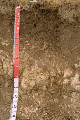 | |
|
Location | Karnak, western Victoria | |||
|
Landform | Rise | |||
|
Geology | Pleistocene Bridgewater Formation: calcareous sand and calcarenite beach ridges | |||
|
Element | Plain | |||
Horizon | Depth (cm) | Description | ||
A1 | 0–10 | Dark brown (7.5YR3/3) with few faint red mottles; light clay; strong medium subangular and polyhedral, parting to fine and very fine subangular and polyhedral structure; weak consistence when dry; pH 8.5: | ||
B2 | 10–40 | Brown (7.5YR4/3) with common faint red mottles; medium heavy clay; strong very fine polyhedral structure; firm consistence; a few soft and hard calcareous nodules; pH 8.5: | ||
C | 40+ | Limestone. | ||
| Management considerations | ||||
| ||||
Horizon | Depth (cm) | pH (water) | pH (CaCl2) | EC dS/m | Exchangeable Cations cmol-/kg | Wilting Point (pF4.2) | Coarse Sand % | Fine Sand % | Silt % | Clay % | |||
Ca | Mg | K | Na | ||||||||||
A1 | 0–10 | 8.5 | 7.8 | 0.11 | 14 | 4 | 1.2 | 0.2 | 15.7 | 27 | 24.6 | 6 | 34.5 |
B2 | 10–40 | 8.5 | 7.7 | 0.11 | 23 | 11 | 2.4 | 0.9 | 26.3 | 15.2 | 12.5 | 6.5 | 56.5 |
C | 40+ | ||||||||||||
© State of Victoria (Agriculture Victoria) 1996 - .

This work, Victorian Resources Online, is licensed under a Creative Commons Attribution 4.0 licence. You are free to re-use the work under that licence, on the condition that you credit the State of Victoria (Agriculture Victoria) as author, indicate if changes were made and comply with the other licence terms.
The licence does not apply to ‘branding’ or some ‘images or photographs’ that may be owned by third parties. We ask you to seek prior approval to use images using the VRO feedback form. Access to higher quality images can also be provided on request.
This page was last updated on .