
LSWW18
|
| LSWW18 | 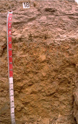 Ferric (and Calcic), Mottled-Mesonatric, Grey SODOSOL | |
|
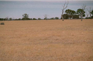
Location | North of Langkoop, western Victoria | |||
|
Landform | Plain | |||
|
Geology | Quaternary swamp and lake deposits: paludal silt and clay | |||
|
Element | Plain | |||
Horizon | Depth (cm) | Description | ||
A1 | 0–25 | Brown (7.5YR4/2); sand; weak structure; weak consistence when dry; pH 5.5; clear boundary to: | ||
A2 | 25–42 | Light brown (7.5YR6/4), conspicuously bleached; sand; massive (structureless); many (some patches 80-100%) ferruginous nodules; pH 6.1; abrupt boundary to: | ||
B21 | 42–50 | Light grey (10YR7/2) with abundant very coarse prominent yellowish brown and dark red mottles; light clay; strong coarse, parting to strong medium polyhedral structure; smooth ped-fabric; some ferruginous nodules; strong consistence when dry (complete dispersion when worked); pH 7.3; clear boundary to: | ||
B22 | 50–85 | Brownish yellow (10YR6/6) with dark red and brownish yellow mottles; light medium clay; strong coarse prismatic, parting to strong coarse blocky structure (some areas parting further to strong medium/fine polyhedral structure); brown clay skins, cutans; few ferruginous nodules; very firm consistence when slightly moist; pH 6.9: | ||
B23 | 85–150 | Brownish yellow (10YR6/6); medium heavy clay (sandy) with patches of yellow (10YR7/8) sand throughout; moderate very coarse prismatic structure; complete dispersion; pH 6.5: | ||
B24 | 150–200+ | Brownish yellow (10YR6/8) with light grey mottles; light clay; common soft calcareous and hard calcareous /silica nodules; pH 9.3. | ||
| Management Considerations | ||||
| ||||
Horizon | Depth (cm) | pH (water) | pH (CaCl2) | EC dS/m | Exchangeable Cations cmol-/kg | Wilting Point (pF4.2) | Coarse Sand % | Fine Sand % | Silt % | Clay % | |||
Ca | Mg | K | Na | ||||||||||
A1 | 0–25 | 5.5 | 4.4 | <0.05 | 0.5 | 0.1 | 0.1 | 0.1 | 3.7 | 55.5 | 30.5 | 3 | 5 |
A2 | 25–42 | 6.1 | 4.8 | <0.05 | 0.1 | <0.1 | <0.1 | 0.1 | |||||
B21 | 42–50 | 7.3 | 6 | 0.06 | 4.2 | 5.9 | 0.5 | 2.2 | 24.4 | 12.3 | 12.6 | 2.5 | 67.5 |
B22 | 50–85 | 6.9 | 6 | 0.09 | 2.6 | 6.4 | 0.4 | 1.9 | 20.1 | 16.7 | 14.5 | 1.5 | 62 |
B23 | 85–150 | 6.5 | 5.2 | 0.07 | 1.3 | 6 | 0.2 | 2.6 | |||||
B24 | 150–200+ | 9.3 | 8.5 | 0.38 | |||||||||
© State of Victoria (Agriculture Victoria) 1996 - .

This work, Victorian Resources Online, is licensed under a Creative Commons Attribution 4.0 licence. You are free to re-use the work under that licence, on the condition that you credit the State of Victoria (Agriculture Victoria) as author, indicate if changes were made and comply with the other licence terms.
The licence does not apply to ‘branding’ or some ‘images or photographs’ that may be owned by third parties. We ask you to seek prior approval to use images using the VRO feedback form. Access to higher quality images can also be provided on request.
This page was last updated on .