
LSWW16
|
| LSWW16 | 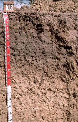 Endocalcareous-Endohypersodic, Self-mulching, Grey VERTOSOL | |
|
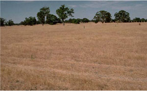
Location | North of Benayeo, western Victoria | |||
|
Landform | Plain | |||
|
Geology | Quaternary swamp and lake deposits: paludal silt and clay | |||
|
Element | Plain | |||
Horizon | Depth (cm) | Description | ||
A1 | 0–10 | Dark greyish brown (10YR4/2); light clay; moderate coarse polyhedral structure; self-mulching surface condition (particularly evident after cultivation); strong consistence when dry; pH 8.6: | ||
B21 | 10–20 | Grey (10YR5/1) with slight brownish yellow (10YR6/8) mottles; medium clay; moderate coarse prismatic, parting to moderate coarse blocky structure; smooth ped fabric; strong consistence when dry (complete dispersion when worked); pH 8.4: Note: Within the upper subsoil there is a discontinuous bleached A2 horizon with a fine sandy clay loam texture. | ||
B22 | 20–40 | Medium clay; lenticular structure and some slickensides; smooth ped fabric; pH 8.7: | ||
B23 | 40–60 | Medium clay; lenticular structure and some slickensides; smooth ped fabric; complete dispersion; pH 8.8: | ||
B24 | 60–80 | Medium clay; smooth ped fabric; pH 9.0 ; | ||
B25 | 80–130 | Medium heavy clay; strong fine lenticular, parting to very fine lenticular structure; smooth ped-fabric; pH 9.3: | ||
B26 | 130–180+ | Heavy clay; some slickensides; smooth ped fabric; few soft and hard calcareous and silica nodules; pH 9.1. | ||
| Management Considerations | ||||
| ||||
Horizon | Depth (cm) | pH (water) | pH (CaCl2) | EC dS/m | NaCl % | Exchangeable Cations cmol-/kg | Wilting Point (pF4.2) | Coarse Sand % | Fine Sand % | Silt % | Clay % | |||
Ca | Mg | K | Na | |||||||||||
A1 | 0–10 | 8.6 | 7.9 | 0.14 | 22 | 5.6 | 1.5 | 0.8 | 20.3 | 7.4 | 28.6 | 7 | 48 | |
B21 | 10–20 | 8.7 | 7.8 | 0.2 | 25.9 | 6.1 | 20.4 | 5 | 58 | |||||
B21 | 10–20 | 8.4 | 7.1 | 0.06 | 6.8 | 2.8 | 0.4 | 0.9 | 8.5 | 14.4 | 47.4 | 12 | 21.5 | |
B22 | 20–40 | 8.7 | 7.5 | 0.25 | 15 | 13 | 1.6 | 6.4 | 4.6 | 15.7 | 8 | 62.5 | ||
B23 | 40–60 | 8.8 | 8 | 0.32 | <0.05 | 13 | 14 | 1.6 | 8.4 | |||||
B24 | 60–80 | 9 | 8.2 | 0.27 | ||||||||||
B25 | 80–130 | 9.3 | 8.5 | 0.74 | 0.07 | 9.2 | 14 | 1.3 | 12 | |||||
B26 | 130–180+ | 9.1 | 8.6 | 1.1 | 0.16 | |||||||||
© State of Victoria (Agriculture Victoria) 1996 - .

This work, Victorian Resources Online, is licensed under a Creative Commons Attribution 4.0 licence. You are free to re-use the work under that licence, on the condition that you credit the State of Victoria (Agriculture Victoria) as author, indicate if changes were made and comply with the other licence terms.
The licence does not apply to ‘branding’ or some ‘images or photographs’ that may be owned by third parties. We ask you to seek prior approval to use images using the VRO feedback form. Access to higher quality images can also be provided on request.
This page was last updated on .