
LSWW13
|
| LSWW13 | 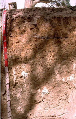 | |
|
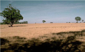
Location | Winter Lake, western Victoria | |||
|
Landform | Plain | |||
|
Geology | Quaternary swamp and lake deposits: paludal silt and clay | |||
|
Element | Plain
| |||
Horizon | Depth (cm) | Description | ||
AO | 0–3 | Organic layer. | ||
A1 | 3–10 | Brown (7.5YR4/2); loamy sand; weakly structured; pH 6.6: | ||
A2 | 10–20 | Pink (7.5YR7/4); sand; massive (structureless); pH 6.3: | ||
B21 | 20–40 | Very pale brown with many distinct brownish yellow mottles (10YR7/3); medium heavy clay; very coarse columnar, parting to strong medium polyhedral, parting to moderate fine polyhedral structure; clay skin cutans; dispersive when worked; pH 5.8: | ||
B22 | 40–70 | Brownish yellow (10YR6/8); sandy clay; completely dispersive; pH 7.2: | ||
B23 | 70–90 | Pale yellow (2.5Y7/4) with a few faint brownish yellow mottles; medium heavy clay, sandy; moderate coarse prismatic, parting to strong coarse blocky structure; a few manganese flecks; completely dispersive; pH 8.5: | ||
B24k | 90–150 | Light grey (2.5Y7/2); medium heavy clay, sandy; moderate coarse prismatic, parting to strong coarse blocky structure; common soft calcareous segregations with a few hard calcareous nodules; carbonate occurs in patches; pH 9.6: | ||
B25 | 150–200+ | Light grey (2.5Y7/2); medium clay, sandy; moderate coarse parting to strong medium polyhedral structure; pH 9.0. | ||
| Management Considerations | ||||
| ||||
Horizon | Depth (cm) | pH (water) | pH (CaCl2) | EC dS/m | NaCl % | Exchangeable Cations cmol-/kg | Wilting Point (pF4.2) | Coarse Sand % | Fine Sand % | Silt % | Clay % | |||
Ca | Mg | K | Na | |||||||||||
AO | 0–3 | 12.6 | ||||||||||||
A1 | 3–10 | 6.6 | 6.3 | 0.18 | 4.2 | 2 | 0.2 | 0.3 | 43 | 29.5 | 5.5 | 10.5 | ||
A2 | 10–20 | 6.3 | 5.7 | 0.05 | 18.0 | |||||||||
B21 | 20–40 | 5.8 | 4.8 | 0.22 | 2.6 | 8.1 | 0.6 | 2.5 | 9.6 | 27.8 | 16.8 | 5.5 | 44 | |
B22 | 40–70 | 7.2 | 6.2 | 0.26 | 1.5 | 5.1 | 0.2 | 2.8 | 15.3 | 39.5 | 30.7 | 5.5 | 22 | |
B23 | 70–90 | 8.5 | 7.7 | 0.55 | 0.1 | 3.2 | 10 | 0.4 | 6.6 | |||||
B24k | 90–150 | 9.6 | 8.9 | 0.74 | 0.12 | |||||||||
B25 | 150–200+ | 9 | 8.2 | 0.53 | 0.11 | |||||||||
© State of Victoria (Agriculture Victoria) 1996 - .

This work, Victorian Resources Online, is licensed under a Creative Commons Attribution 4.0 licence. You are free to re-use the work under that licence, on the condition that you credit the State of Victoria (Agriculture Victoria) as author, indicate if changes were made and comply with the other licence terms.
The licence does not apply to ‘branding’ or some ‘images or photographs’ that may be owned by third parties. We ask you to seek prior approval to use images using the VRO feedback form. Access to higher quality images can also be provided on request.
This page was last updated on .