LSWW09
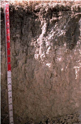
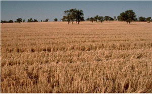
|  Epicalcareous-Endohypersodic, Self-mulching, Grey Vertosol | |||
|
Location | Leeor, western Victoria | |||
|
Landform | Plain | |||
|
Geology | Quaternary Woorinen Formation: aeolian dune sand, calcareous clay | |||
|
Element | Plain | |||
Horizon | Depth (cm) | Description | ||
A1 | 0–10 | Very dark grey (10YR3/1); light medium clay; self–mulching surface condition; moderate coarse blocky, parting to fine polyhedral structure; pH 8.3: | ||
B21 | 10–25 | Dark grey (10YR4/1); light medium clay; moderate coarse blocky structure; smooth ped-fabric, some rough faces due to compaction; pH 8.7: | ||
B22 | 25–55 | Dark reddish grey (2.5Y4/1); light medium clay; moderate coarse, parting to strong coarse blocky, parting further to moderate medium blocky structure; very strong consistence when dry; few soft calcareous segregations; pH 9.2: | ||
B23k | 55–110 | Light grey (2.5Y7/2); light clay; moderate coarse prismatic, parting to moderate medium blocky structure; many soft calcareous segregations; pH 9.7: | ||
B24 | 110–190+ | Light grey (2.5Y7/2); medium heavy clay; strong lenticular structure; few small slickensides; pH 9.6. | ||
| Management Considerations | ||||
| ||||
Horizon | Depth (cm) | pH (water) | pH (CaCl2) | EC dS/m | NaCl % | Exchangeable Cations cmol-/kg | Wilting Point (pF4.2) | Coarse Sand % | Fine Sand % | Silt % | Clay
% | |||
Ca | Mg | K | Na | |||||||||||
A1 | 0–10 | 8.3 | 7.7 | 0.17 | 26 | 4.3 | 2.3 | 0.3 | 22.4 | 5.2 | 23.6 | 7 | 51.5 | |
B21 | 10–25 | 8.7 | 7.9 | 0.13 | 24 | 8.6 | 2 | 1 | 27.7 | 4.2 | 17.4 | 7.5 | 58 | |
B22 | 25–55 | 9.2 | 8.3 | 0.22 | 15 | 12 | 1.7 | 4.1 | 4.4 | 19.2 | 10 | 54.5 | ||
B23k | 55–110 | 9.7 | 8.7 | 0.48 | <0.05 | 31.5 | ||||||||
B24 | 110–190+ | 9.6 | 8.7 | 1 | 0.2 | 3.6 | 17 | 2.1 | 13 | |||||


