
LS6
Location: Diapur Ridge
Australian Soil Classification: Calcic, Mottled-Hypernatric, Grey SODOSOL (sandy)
Northcote Factual Key: Dy5.43
Great Soil Group: solodized solonetz
General Landscape Description: Lower slope on the eastern flank of a north-south trending ridge. Slope 4%. Shallow erosion gullies (1-1.5 m deep) are present.
Native Vegetation: Yellow Gum (Eucalyptus lecoxylon) is the dominant tree species.
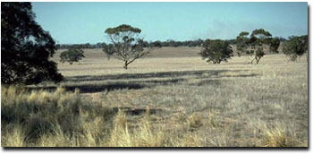 LS6 Landscape |
Soil Profile Morphology:
Surface Soil
| A1 | 0-15 cm | Very dark greyish brown (10YR3/2); loamy sand; weakly structured; weak consistence dry; pH 6.1: | 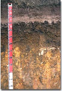 LS6 Profile |
| A2 | 15-20 cm | Conspicuously bleached; loamy sand; structureless; weak consistence dry; contains a common (10 %) amount of ironstone nodules; pH 7.4; sharp change to: | |
| A3 | 20-21 cm | Conspicuously bleached; cemented sand capping; pH 7.8: | |
Subsoil | |||
| B21 | 21-35 cm | Dark greyish brown (10YR4/2) with yellowish brown (10YR5/4) and strong brown (7.5YR4/6) mottles; heavy clay; moderate columnar structure; very strong consistence dry; pH 8.3: | |
| B22 | 35-65 cm | Yellowish brown (10YR5/6) with yellowish red (5YR5/6) mottles; medium heavy clay; strong prismatic, breaking to strong blocky structure; strong consistence moist; contains very few (2 %) ironstone nodules and many (50 %) soft calcareous segregations; pH 8.9: | |
| C | 65+ cm | Weathered sandstone. | |
Key Profile Features:
- Strong texture contrast between sandy surface (A) horizons and subsoil (B21) horizon.
- Non hardsetting nature of surface soil.
- Coarse columnar structure at top of subsoil.
Soil Profile Characteristics:
pH | Salinity | |||
Surface (A1 horizon) | Slightly Acid | Very Low | Non-Sodic | None |
Subsoil (B21 horizon) | Moderately Alkaline | Very Low | Strongly Sodic | Complete |
Deeper Subsoil (at 1 metre) | Strongly Alkaline | Moderate | Strongly Sodic | Strong |
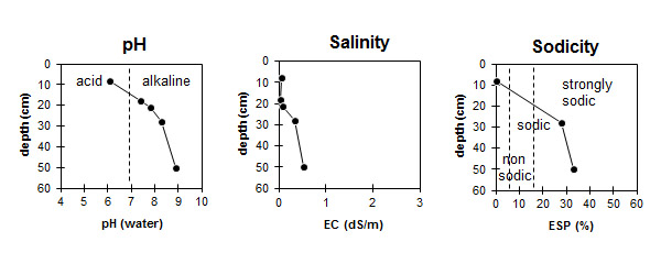
| The surface soil is slightly acid. The subsoil is moderately alkaline becoming strongly alkaline with depth. | The salinity rating is very low in the surface and upper subsoil becoming moderate with depth. | The surface is non-sodic. The subsoil is strongly sodic. |
Chemical and Physical Analysis:
Horizon | Horizon Depth (cm) | pH (water) | pH (CaCl2) | EC dS/m | Exchangeable Cations | |||
Ca | Mg | K | Na | |||||
meq/100g | ||||||||
A1 | 0-15 | 6.1 | 5.0 | 0.05 | 1.6 | 0.5 | 0.3 | 0.1 |
A2 | 15-20 | 7.4 | 6.1 | <0.05 | 0.7 | 0.4 | 0.1 | 0.8 |
A3 | 20-21 | 7.8 | 6.4 | 0.07 | 1.1 | 1.0 | 0.2 | 1.2 |
B21 | 21-35 | 8.3 | 7.3 | 0.33 | 6.5 | 7.9 | 0.6 | 5.6 |
B22 | 35-65 | 8.9 | 8.0 | 0.53 | 6.7 | 9.5 | 0.8 | 8.3 |
Horizon | Horizon Depth (cm) | Oxidisable Organic Carbon % | Total Nitrogen % | Field Capacity pF2.5 | Wilting Point pF4.2 | Coarse Sand (0.2-2.0 mm) % | Fine Sand (0.02-0.2 mm) % | Silt (0.002-0.02 mm) % | Clay (<0.002 mm) % |
A1 | 0-15 | 1.1 | 0.08 | 7.6 | 3.9 | ||||
A2 | 15-20 | 4.4 | 1.8 | ||||||
A3 | 20-21 | ||||||||
B21 | 21-35 | 37.5 | 23.8 | 22 | 25 | 4 | 44 | ||
B22 | 35-65 |
Management Considerations:
Surface (A) Horizons
- The surface horizon has a moderate amount of organic carbon and nitrogen but a very low nutrient status overall. Trace element (e.g. zinc and copper) deficiency may occur. Organic matter is important in these light textured soils for holding nutrients.
- The surface horizon has a low plant available water holding capacity due to the sandy texture. However, the low wilting point value (ie. 4 %) indicates that plants will be able to utilise light rains falling on relatively dry soil.
- The sandy surface horizons are prone to wind erosion. Removal of these horizons would expose the highly dispersible subsoil to water erosion and could lead to gully erosion.
- After heavy rainfall, saturation of the subsurface (ie. A2) horizon is likely to occur above the relatively impermeable B horizon. The conspicuous bleaching indicates that this horizon is periodically waterlogged.
- The surface horizon is non hard-setting and weakly coherent; therefore it should not restrict seedling emergence and is relatively easy to work.
- Water infiltration rates are high. However, in some instances the dry sandy surfaces may develop water repellent properties which reduces initial wetting up and hence infiltration.
Subsoil (B) Horizons
- The strongly sodic subsoils which disperse completely are likely to restrict water and root movement down the profile from 25 cm and below. The hard capping on top of the subsoil columnar structure will also be restrictive. Restricted root movement through the subsoil will reduce the ability of crops to utilise subsoil moisture and nutrients.
Comments from Landholder:
- Prone to gully erosion. The gullying at this site is largely the result of poor contouring in 1954 and a subsequent heavy rainfall event.
- Used for pasture (rye grass and clover) only due to high erodibility.
Profile Described By: Mark Imhof, John Martin, Sonia Thompson (May 1994).
© State of Victoria (Agriculture Victoria) 1996 - .

This work, Victorian Resources Online, is licensed under a Creative Commons Attribution 4.0 licence. You are free to re-use the work under that licence, on the condition that you credit the State of Victoria (Agriculture Victoria) as author, indicate if changes were made and comply with the other licence terms.
The licence does not apply to ‘branding’ or some ‘images or photographs’ that may be owned by third parties. We ask you to seek prior approval to use images using the VRO feedback form. Access to higher quality images can also be provided on request.
This page was last updated on .