
LS2
Location: Kinimakatka
Australian Soil Classification: Vertic (and Calcic), Mottled-Subnatric, Brown SODOSOL
Northcote Factual Key: Db 2.13
Great Soil Group: red-brown earth (sodic)
General Landscape Description: Lower slope on the eastern side of a north-south trending Gently Undulating Rise. Average slope 3-4%.
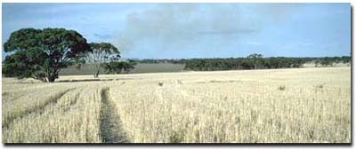 LS2 Landscape |
Soil Profile Morphology:
Surface Soil
| A1 | 0-10 cm | Dark brown (10YR3/3); sandy clay loam; weakly structured; weak consistence dry; pH 6.2; sharp boundary change to: | 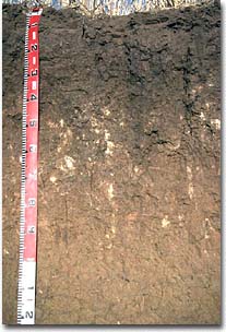 LS2 Profile |
| Subsoil | |||
| B21 | 10-40 cm | Dark brown (10YR3/3) with faint reddish brown (5YR4/4) mottles; medium heavy clay; moderate coarse prismatic, parting to moderate coarse blocky structure; very strong consistence dry; contains few (5 %) ironstone concretions; pH 7.8: | |
| B22 | 40-80 cm | Light brownish grey (10YR6/2) with yellow red (5YR5/6); medium heavy clay; structure similar to above; contains few (7 %) soft carbonate segregations in pockets; pH 9.4: | |
| B23 | 80-100 cm | Greyish brown (2.5Y5/2) with yellowish red (5YR4/6) mottles; medium heavy clay; pH 9.3: | |
| B24 | 100-130 cm | Olive brown (2.5Y6/4) with red mottles; heavy clay; strong lenticular structure; pH 9.2. | |
Key Profile Features:
- Texture contrast below surface horizon and clay subsoil horizons.
- Hardsetting nature of the surface soil.
- Vertic properties (ie. presence of lenticular structure) in deeper subsoil.
Soil Profile Characteristics:
| - | pH | Salinity | ||
Surface (A1 horizon) | Slightly Acid | Very low | Non-Sodic | None 1 |
Subsoil (B21 horizon) | Slightly Alkaline | Very low | Sodic | Moderate-Strong |
Deeper Subsoil (at 1 metre) | Very Strongly Alkaline | High | Strongly Sodic | Moderate- Strong |
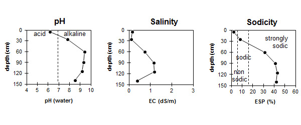
| The surface soil is slightly acid. The subsoil is slightly alkaline becoming very strongly alkaline with depth. | The salinity rating is very low in the surface and upper subsoil becoming high with depth. | The surface is non-sodic. The subsoil is sodic becoming strongly sodic with depth.. |
Chemical and Physical Analysis:
Horizon | Horizon Depth (cm) | pH (water) | pH (CaCl2) | EC dS/m | Sodium Chloride % | Exchangeable Cations | |||
Ca | Mg | K | Na | ||||||
meq/100g | |||||||||
A1 | 0-10 | 6.2 | 5.4 | 0.15 | 6.1 | 2.1 | 0.8 | 0.1 | |
B21 | 10-40 | 7.8 | 6.8 | 0.1 | 10.2 | 5.9 | 0.9 | 1.4 | |
B22 | 40-80 | 9.4 | 8.7 | 0.73 | 7.5 | 12.1 | 0.8 | 8.9 | |
B23 | 80-100 | 9.3 | 8.8 | 1.16 | 0.17 | 4.3 | 10.8 | 1 | 11.2 |
B24 | 100-130 | 9.2 | 8.7 | 1.18 | 0.21 | 4.1 | 9.7 | 0.9 | 10.7 |
B25 | 130+ | 8.5 | 7.9 | 0.39 | 4.6 | 11.9 | 1 | 12.5 | |
Horizon | Horizon Depth (cm) | Total Nitrogen % | Oxidisable Organic Carbon % | Field Capacity pF2.5 | Wilting Point pF4.2 |
A1 | 0-10 | 0.14 | 1.8 | 17.2 | 6 |
B21 | 10-40 | 25.9 | 11.7 | ||
B22 | 40-80 | ||||
B23 | 80-100 | ||||
B24 | 100-130 | ||||
B25 | 130+ |
Management Considerations:
Surface (A) Horizon
- When dry the surface soil will set hard and become difficult to work.
- Although surface soil aggregates are reasonably water-stable, dispersion can occur after mechanical shearing during cultivation when in a moist to wet condition (as indicated by strong dispersion after remoulding). This would result in surface soil structural condition decline which may restrict seedling emergence and water infiltration. Raindrop action on bare soil can have a similar effect, so it is important to maintain surface cover.
- The sodic and dispersive subsoil (from 10cm depth) may create structural problems likely to restrict water and plant root movement down the profile.
- The level of soluble salts is likely to restrict the growth of salt sensitive plants from 40 cm depth.
- The subsoil from 40 cm depth is very strongly alkaline. This indicates that some nutrients (eg. iron, manganese, copper and zinc) may be poorly available to plants at depth. Plant tissue analysis can be used to determine if deficiencies occur.
- Gypsum used successfully.
- Good wheat yields achieved.
© State of Victoria (Agriculture Victoria) 1996 - .

This work, Victorian Resources Online, is licensed under a Creative Commons Attribution 4.0 licence. You are free to re-use the work under that licence, on the condition that you credit the State of Victoria (Agriculture Victoria) as author, indicate if changes were made and comply with the other licence terms.
The licence does not apply to ‘branding’ or some ‘images or photographs’ that may be owned by third parties. We ask you to seek prior approval to use images using the VRO feedback form. Access to higher quality images can also be provided on request.
This page was last updated on .