
LS14a
Location: Propodollah.
Australian Soil Classification: Hypercalcic, Subnatric, Red SODOSOL (sandy)
Northcote Factual Key: Dy 5.43
Great Soil Group: solonetz/solodized solonetz (intermixed)
General Landscape Description: Lower slope of dune on gently undulating sand plain.
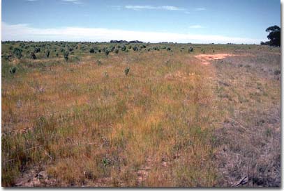 LS14a Landscape |
Soil Profile Morphology:
Surface Soil
| A1 | 0-20 cm | Dark brown (7.5YR3/4); loamy sand; structureless; weak consistence dry; pH 6.6: | 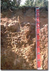 LS14a Profile |
| A2 | 20-30 cm | Yellowish red (5YR4/6); sand; massively structured; firm consistence dry; pH 6.5: | |
| Subsoil | |||
| B21 | 30-35 cm | Yellowish red (5YR5/8); heavy clay; strong coarse columnar (with bleached cemented capping), breaking to strong coarse blocky structure; very strong consistence dry; pH 8.6: | |
| B22 | 35-65 cm | Brown yellow (10YR6/8) with red (2.5YR4/8) mottles; light medium clay; weaker columnar structure; strong consistence dry; contains many (20-50%) soft carbonates; pH 9.3. |
Key Profile Features:
- Distinctive texture contrast between sandy surface (A) horizons and clay (B) subsoil.
Strong coarse columnar structure with bleached capping at top of subsoil.
Soil Profile Characteristics:
| - | pH | Salinity | ||
Surface (A1 horizon) | Slightly Acid | Very Low | Non-Sodic | _ |
Subsoil (B21 horizon) | Strongly Alkaline | Medium | Sodic | Moderate |
Deeper Subsoil (at 0.5 metres) | Extremely Alkaline | Medium-High | Strongly Sodic | _ |
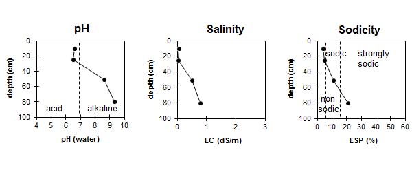
| The surface soil is slightly acid. The subsoil is strongly alkaline becoming extremely alkaline at depth. | The salinity rating is very low in the surface. The subsoil is moderate becoming high with depth. | The surface is non-sodic. The subsoil is sodic becoming strongly sodic with depth. |
Chemical and Physical Analysis:
Horizon | Horizon Depth (cm) | pH (water) | pH (CaCl2) | EC dS/m | Sodium Chloride % | Oxidisable Organic Carbon % | Total Nitrogen % | Exchangeable Cations | |||
Ca | Mg | K | Na | ||||||||
meq/100g | |||||||||||
A11 | 0-20 | 6.6 | 6 | 0.05 | 0.83 | 0.05 | 2.3 | 0.4 | 0.3 | 0.1 | |
A12 | 20-30 | 6.5 | 5.5 | <0.05 | 1.5 | 0.4 | 0.1 | 0.1 | |||
B21 | 30-70 | 8.6 | 7.9 | 0.5 | 0.09 | 8.7 | 12 | 0.9 | 2.5 | ||
B22 | 70+ | 9.3 | 8.5 | 0.78 | 0.12 | 4.5 | 10 | 0.7 | 4 | ||
Horizon | Horizon Depth (cm) | Field Capacity pF2.5 | Wilting Point pF4.2 |
A11 | 0-20 | 5.7 | 2.6 |
A12 | 20-30 | ||
B21 | 30-70 | 32.7 | 21 |
B22 | 70+ |
Management Considerations:
Surface (A) Horizons
- Sandy surface horizons have a very low nutrient status as well as low levels of total nitrogen and organic carbon. Organic matter levels are important for holding nutrients in such light textured soils.
- The available water capacity is very low for the surface horizons due to its sandy texture. However, the low wilting point (15%) means that plants will be able to utilise light rain falling on relatively dry soil.
- Susceptible to wind erosion if surface cover is inadequate. Removal of surface horizons would result in the subsoil being exposed to water erosion forces.
Subsoil (B) Horizons
- The subsoil is sodic and disperses when wet. The top of the subsoil also has a hard cemented capping which is likely to restrict root movement and water movement.
- Soluble salts in the subsoil may restrict growth of salt sensitive plant.
Comments from Landholder:
- Mallee cleared around 1900.
- Salt bush grown for 2 years.
- Superphosphate applied in 1992
- Skeleton weed is a problem.
- Chisel plough used for cultivation.
© State of Victoria (Agriculture Victoria) 1996 - .

This work, Victorian Resources Online, is licensed under a Creative Commons Attribution 4.0 licence. You are free to re-use the work under that licence, on the condition that you credit the State of Victoria (Agriculture Victoria) as author, indicate if changes were made and comply with the other licence terms.
The licence does not apply to ‘branding’ or some ‘images or photographs’ that may be owned by third parties. We ask you to seek prior approval to use images using the VRO feedback form. Access to higher quality images can also be provided on request.
This page was last updated on .