
LP82
Location: Frenchmans
Australian Soil Classification: Bleached-Sodic, Mesotrophic, Brown CHROMOSOL
Northcote Factual Key: Dy 4.42
General Landscape Description: Lower slope (10%) of a hill slope within a rolling hills unit.
Site Description: Grazing.
Geology: Cambrian sediments. Warrack Formation: marine sediments (sandstone, siltstone, schist and slate).
Original Vegetation: Included Red Stringybark (Eucalyptus macrorhyncha), Long-leaf Box (E. goniocalyx) and Grey Box (E. microcarpa). Kangaroo Grass (Themeda australis) is widespread now.
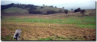 LP82 Landscape |
Soil Profile Morphology:
Surface Soil
| A1 | 0-7 cm | Very dark greyish brown (10YR3/2); fine sandy loam; firm surface condition with few surface quartz gravels; weakly structured; very weak consistence dry; contains very few (4%) sandstone fragments (5 mm diameter); pH 6.2; clear change to: | 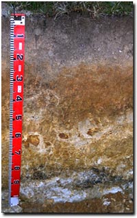 LP82 Profile |
| A2 | 7-20 cm | Conspicuously bleached (10YR7/2d); fine sandy clay loam (silty); weakly structured; weak consistence moist; contains many (40%) sandstone fragments (8 mm diameter), as well as quartz (15 mm diameter); pH 6.3; abrupt change to: | |
| Subsoil | |||
| B1 | 20-23 cm | Light yellowish brown (10YR6/4); light medium clay; weakly structured; firm consistence moist; contains very few (1%) sandstone fragments (< 5 mm diameter); pH 6.5; abrupt change to: | |
| B21 | 23-50 cm | Yellowish brown (10YR5/8); medium heavy clay; strong medium polyhedral structure; firm consistence moist; contains very few (1%) sandstone fragments (< 5 mm diameter); pH 6.4; sharp change to: | |
| B22 | 50-85 cm | Yellowish brown (10YR5/8); medium clay; strong medium polyhedral structure; very firm consistence dry; contains many (20-50%) sandstone fragments (10-15 cm diameter); pH 6.6; clear change to: | |
| B3 | 85+ cm | Weathered sandstone/soft mudstone/siltstone with clay bands; clay has a strong coarse prismatic structure; contains manganese flecks; pH 7.2. | |
Key Profile Features:
- Strong texture contrast between surface (A) horizons and the upper subsoil (B21) horizon.
- Very gravelly and bleached subsurface (A2) horizon.
- Weathered rock at 85 cm.
Soil Profile Characteristics:
pH | Salinity Rating | |||
Surface (A1 horizon) | Slightly Acid | Very Low | Non-Sodic | None1 |
Subsoil (B1 horizon) | Slightly Acid | Very Low | Non-Sodic | None |
Deeper Subsoil (at 85+ cm) | Slightly Alkaline | Very Low-Low | Sodic | Slight2 |
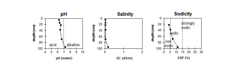
| The surface is slightly acid. The subsoil is slightly acid becoming slightly alkaline with depth. | The profile has a very low salinity rating throughout. | The surface and upper subsoil is non-sodic. The deeper subsoil is sodic. |
Chemical and Physical Analysis:
Horizon | Horizon Depth (cm) | pH (water) | pH (CaCl2) | EC dS/m | Nitrogen % | Organic Carbon % | Exchangeable Cations | |||
Ca | Mg | K | Na | |||||||
Meq/100g | ||||||||||
A1 | 0-7 | 6.2 | 5.1 | <0.05 | 0.11 | 1.9 | 3.4 | 0.9 | 0.3 | <0.1 |
A2 | 7-20 | 6.3 | 5.1 | <0.05 | 1.9 | 0.8 | 0.3 | <0.1 | ||
B1 | 20-23 | 6.5 | 5.2 | <0.05 | 1.3 | 1.5 | 0.3 | 0.1 | ||
B21 | 23-50 | 6.4 | 5.3 | <0.05 | 1.3 | 4.7 | 0.4 | 0.3 | ||
B22 | 50-85 | 6.6 | 5.4 | <0.05 | 0.7 | 4.8 | 0.2 | 0.4 | ||
B23 | 85+ | 7.2 | 7.9 | 0.16 | 0.7 | 18 | 0.3 | 2.3 | ||
Horizon | Horizon Depth (cm) | Field Capacity pF2.5 | Wilting Point pF4.2 | Coarse Sand (0.2-2.0mm) | Fine Sand (0.02-0.2mm) | Silt (0.002-0.02mm) | Clay (<0.002mm) |
A1 | 0-7 | 28.1 | 7.3 | 9 | 49 | 27 | 14 |
A2 | 7-20 | 19 | 37 | 27 | 14 | ||
B1 | 20-23 | ||||||
B21 | 23-50 | 33.9 | 16.7 | ||||
B22 | 50-85 | 32.4 | 14.8 | ||||
B23 | 85+ |
Management Considerations:
Whole Profile
- The whole profile has a low inherent fertility (based on the sum of the basic exchangeable cations).
- The surface (A1) horizon is shallow. It is important to preserve this horizon by maintaining adequate surface cover and prevent sheet erosion on sloping ground. Organic matter is important for surface soils such as these with a high fine sand and silt content (ie. 76%). Increasing organic matter contents enhances soil fertility, aggregate stability and water holding capacity.
- The very gravelly subsurface (A2) horizon may deflect roots of species that have a tap root system.
- The bleached subsurface (A2) horizon indicates that periodic waterlogging occurs on top of the more slowly permeable subsoil. This horizon is likely to become 'spewy' as a result.
- The subsoil is sodic from 50 cm but is not dispersive. Some restriction to water and root movement in the deeper subsoil would be expected.
- The subsoil is quite well structured which should allow reasonable root penetration.
- The subsoil has a high percentage of exchangeable magnesium relative to other basic cations. Nutrient imbalances may occur as a result (e.g. calcium deficiency).
- Currently stocked at 1-2 sheep per acre.
- Pasture (native grasses mainly) responds well to superphosphate.
Profile Described By: Paul Rampant, Sonia Thompson and Ruth Lourey (June 1995).
© State of Victoria (Agriculture Victoria) 1996 - .

This work, Victorian Resources Online, is licensed under a Creative Commons Attribution 4.0 licence. You are free to re-use the work under that licence, on the condition that you credit the State of Victoria (Agriculture Victoria) as author, indicate if changes were made and comply with the other licence terms.
The licence does not apply to ‘branding’ or some ‘images or photographs’ that may be owned by third parties. We ask you to seek prior approval to use images using the VRO feedback form. Access to higher quality images can also be provided on request.
This page was last updated on .