
ESAS5
Location: Rupanyup
Australian Soil Classification: Epicalcareous-Endohypersodic, Self-Mulching, Grey VERTOSOL
General Landscape Description: Level plain.
Site Description: Cropping paddock.
Geology: Quaternary alluvial and aeolian deposition.
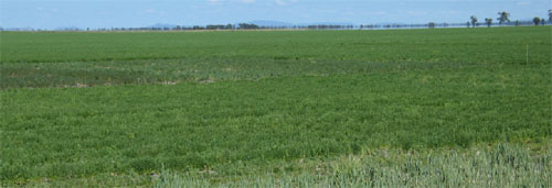 ESAS5 Landscape |
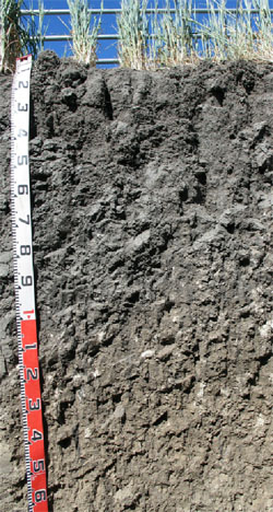
Soil Profile Morphology:
Surface Soil
| Ap | 0-5 cm | Grey (10YR5/1); light clay; self-mulching and surface cracking ; pH 7.9: |
 ESAS5 Profile |
| Subsoil | |||
| B21 | 5-30 cm | Grey (2.5Y5/1); medium clay; moderate very coarse (>50 mm) blocky (probably compacted) structure; strong consistence dry; pH 8.4; gradual change to: | |
| B22 | 30-70 cm | Grey (2.5Y5/1); heavy clay; strong coarse to medium (10-50 mm) sub-angular blocky, parting to moderate to strong coarse to medium (10-50 mm) lenticular structure; strong consistence dry; very few (1%) soft (2-5 mm) calcareous nodules; pH 8.8; wavy and gradual change to: | |
| B23 | 70-110 cm | Grey (2.5Y5/1); heavy clay; strong consistence dry; very few (1-3%) calcareous nodules; pH 9.0; diffuse change to: | |
| B31k | 110-150 cm | Pale brown (10YR6/3); heavy clay; strong very coarse to coarse (50 - >100 mm) prismatic, parting to strong coarse (20-50 mm) strong sub-angular blocky structure; few (5-10%) slightly soft and some semi-hard calcareous nodules; pH 9.2; diffuse change to: | |
| B32k | 150 +cm | Light grey (2.5Y7/2); medium heavy clay; pH 9.2. | |
Soil Profile Characteristics:
| - | pH | Salinity | ||
Surface (Ap horizon) | Slightly Alkaline | Very Low | Non-Sodic | None |
Subsoil (B21 horizon) | Moderately Alkaline | Very Low | Non-Sodic | None |
Deeper Subsoil (at 1.5 metres) | Very Strongly Alkaline | Medium-High | Strongly Sodic | Strong |
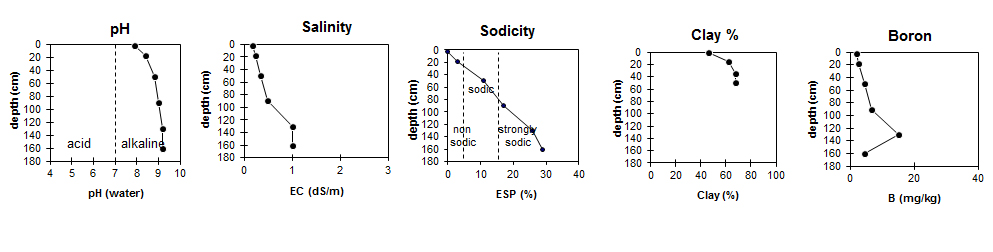
| The surface soil is slightly alkaline. The subsoil is moderately alkaline becoming very strongly alkaline with depth. | The salinity rating is very low in the surface and upper subsoil becoming high with depth. | The surface is non-sodic. The upper subsoil is non-sodic becoming strongly sodic (and dispersive) with depth. | The clay content is high throughout the profile | Boron levels are quite high below one metres depth. |
Chemical and Physical Analysis:
Horizon | Horizon Depth (cm) | pH (water) | pH (CaCl2) | EC dS/m | Exchangeable Cations | |||
Ca | Mg | K | Na | |||||
meq/100g | ||||||||
Ap | 0-5 | 7.9 | 7.4 | 0.18 | 29 | 7.7 | 2.8 | 0.22 |
B21 | 5-30 | 8.4 | 7.8 | 0.23 | 35 | 12 | 1.7 | 1.7 |
B22 | 30-70 | 8.8 | 8.1 | 0.35 | 22 | 17 | 1.8 | 5.2 |
B23 | 70-110 | 9 | 8.2 | 0.49 | 19 | 19 | 2 | 8.2 |
B31K | 110-150 | 9.2 | 8.6 | 1 | 11 | 19 | 1.8 | 11 |
B32 | 150+ | 9.2 | 8.6 | 1.0 | 9 | 19 | 1.7 | 12 |
Horizon | Horizon Depth (cm) | Oxidisable Organic Carbon % | Total Nitrogen % | Boron mg/kg | Field Capacity pF2.5 | Wilting Point pF4.2 | Coarse Sand (0.2-2.0 mm) | Fine Sand (0.02-0.2 mm) | Silt (0.002-0.02 mm) | Clay (<0.002 mm) |
Ap | 0-5 | 1.4 | 0.11 | 2.0 | 42.1 | 21.8 | 12 | 17 | 17 | 46 |
B21 | 5-30 | 0.59 | <0.05 | 2.6 | 52 | 28.8 | 9 | 14 | 10 | 62 |
B22 | 30-70 | 4.6 | 54.1 | 29.1 | 8 | 12 | 7 | 68 | ||
B23 | 70-110 | 6.6 | ||||||||
B31K | 110-150 | 15 | ||||||||
B32 | 150+ | 4.5 |
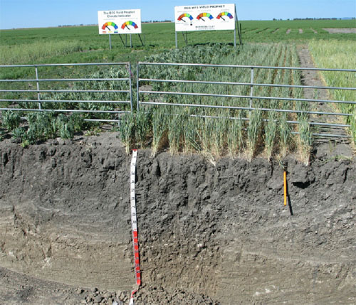
ESAS5 Trial site.
Profile Described By: Mark Imhof (October 2006).
© State of Victoria (Agriculture Victoria) 1996 - .

This work, Victorian Resources Online, is licensed under a Creative Commons Attribution 4.0 licence. You are free to re-use the work under that licence, on the condition that you credit the State of Victoria (Agriculture Victoria) as author, indicate if changes were made and comply with the other licence terms.
The licence does not apply to ‘branding’ or some ‘images or photographs’ that may be owned by third parties. We ask you to seek prior approval to use images using the VRO feedback form. Access to higher quality images can also be provided on request.
This page was last updated on .