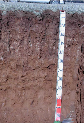
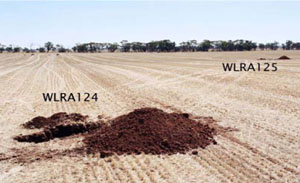
WLRA124
|
| WLRA124 |  Hypercalcic, Mesonatric, Red Sodosol | |
|
Location | Borung Highway, Areegra, western Victoria | |||
|
Landform | Crest of an undulating plain | |||
|
Geology | Quaternary Woorinen Formation: aeolian dune sand, calcareous clay | |||
|
Element | Rise crest | |||
|
Slope | 2–3% | |||
|
Aspect | South-west | |||
Horizon | Depth (cm) | Description | ||
A1 | 0–10 | Dark brown (7.5YR3/3); light sandy clay loam; weakly pedal to single grain (structureless); weak consistence when dry; pH 7.5; smooth and sharp boundary to: | ||
B21 | 10–25 | Dusky red (2.5YR3/4); medium clay; medium to coarse strong angular blocky, parting to fine to very fine subangular blocky structure; smooth ped fabric; very firm consistence when dry; very few manganiferous flecks (<2 mm) and root linings (2-6 mm), slightly calcareous, pH 8.5; clear and irregular boundary to: | ||
B22k | 25–55 | Yellowish red (5YR5/6); medium clay; medium strong prismatic, parting to fine subangular blocky structure; rough ped fabric; very firm consistence when dry; very highly calcareous with many coarse to very coarse soft calcareous segregation's; many fine pores and roots; pH 9.0; clear and irregular boundary to: | ||
B23 | 55–85 | Yellowish red (5YR5/6); light medium clay; strong fine prismatic, parting to strong very fine subangular blocky structure; rough ped fabric; very firm consistence when dry; many fine pores and roots; pH 9.0; smooth and gradual boundary to: | ||
B3 | 85–125+ | Yellowish red (5YR5/5); light medium clay; weak fine prismatic, parting to very fine subangular blocky structure; rough ped fabric; firm consistence when moderately moist; many fine pores; pH 9.0. | ||
| Management considerations | ||||
| ||||
Site WLRA124 | Sample depth cm | pH | EC dS/m | NaCl % | Ex Ca cmol-/kg | Ex Mg cmol-/kg | Ex K cmol-/kg | Ex Na cmol-/kg | Ex Al mg/kg | Ex acidity cmol-/kg | FC -30okPa | PWP -1500okPa | KS % | FS % | Z % | C % | |
Horizon | H2O | CaCl2 | |||||||||||||||
A1 | 0–10 | 7.6 | 7.1 | 0.14 | 0.08 | 1.3 | 2 | 2.7 | 1.6 | 0.24 | 2.7 | Considerable | 3(2) | 50 | 21.6 | 5 | 19.5 |
B21 | 10–25 | 8.4 | 8 | 0.24 | NA | NA | 5.9 | 10 | 1.2 | 1.6 | 10 | Considerable | 2(1) | 24.4 | 14.2 | 4 | 53.5 |
B22k | 25–55 | 9.3 | 8.6 | 0.33 | NA | NA | 16 | 12 | 1.4 | 5 | 12 | Considerable | 2(3) | 18.1 | 15.5 | 6 | 51.5 |
B23 | 55–85 | 9.6 | 9 | 0.61 | NA | NA | 24 | 13 | 2 | 10 | 13 | Partial | 2(3) | 16.3 | 16.6 | 3.5 | 56 |
B3 | 85–125+ | 9.7 | 9 | 0.78 | NA | NA | 21 | 12 | 2.3 | 12 | 12 | Partial | 2(3) | 14.8 | 14 | 4 | 59.5 |
Description of sample | pH | E.C.
dS/m | T.S.S.
% w/w | Total C
% w/w | Org.Mat
% w/w | Total N
% w/w | Olsen P
mg/kg | Skene K
mg/kg | CPC S
mg/kg | Field BD
kg/L | |
H2O | CaCl2 | ||||||||||
WLRA126 bulk sample (A1) | 8.2 | 7.9 | 0.23 | NR | NR | NR | NR | 20 | 840 | 14 | NR |


