
LS4
|
| LS4 | 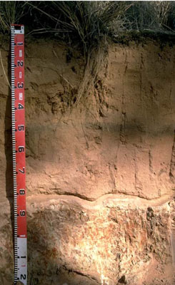 Eutrophic, Mottled-Subnatric, Grey Sodosol (deep sandy) | |
|
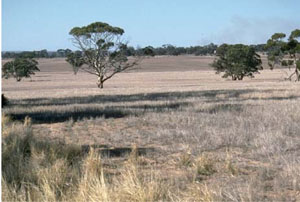
Location | Diapur, western Victoria | |||
|
Landform | Ridge | |||
|
Geology | Pliocene Parilla Sand: marine sand and silt | |||
|
Element | Hillslope (crest) | |||
|
Aspect | 3–5% | |||
Horizon | Depth (cm) | DescriptionEastWestWest | ||
A11 | 0–5 | Very dark greyish brown (10YR3/2); loamy sand; weak granular structure; weak consistence (dry); pH 6.5. | ||
A12 | 5–45 | Dark yellowish brown (10YR4/6); sand; single grain (structureless); pH 6.7. | ||
A13 | 45–50 | Dark reddish brown (5YR3/3); loamy sand; pH 6.2. | ||
A14 | 50–80 | Yellowish red (5YR4/8); sand with a common (10-20%) amount of ferruginous nodules; pH 6.7. | ||
B21 | 80–110 | Very pale brown (10YR7/3) and (2.5YR3/8) mottles; heavy clay; coarse columnar, parting to strong coarse prismatic structure; hard bleached capping at top of columnar structure; very strong consistence (dry); pH 6.5. | ||
C | 110+ | Weathered sandstone. | ||
| Management considerations | ||||
| ||||
Site LS4 | Sample depth cm | pH | EC dS/m | NaCl % | Ex Ca cmol-/kg | Ex Mg cmol-/kg | Ex K cmol-/kg | Ex Na cmol-/kg | Ex Al mg/kg | Ex acidity cmol-/kg | FC -30okPa | PWP -1500okPa | KS % | FS % | Z % | C % | |
Horizon | H2O | CaCl2 | |||||||||||||||
A11 | 0–5 | 6.5 | 5.8 | <0.05 | NA | 2.7 | 0.5 | 0.1 | <0.1 | NA | NA | 4.4 | 4.3 | NA | NA | NA | NA |
A12 | 5–45 | 6.7 | 5.8 | <0.05 | NA | 0.6 | 0.2 | <0.1 | <0.1 | NA | NA | 3.5 | 0.9 | NA | NA | NA | NA |
A13 | 45–50 | 6.2 | 5 | <0.05 | NA | 1.1 | 0.3 | 0.1 | <0.1 | NA | NA | NA | NA | NA | NA | NA | NA |
A14 | 50–80 | 6.7 | 5.7 | <0.05 | NA | 0.7 | 0.3 | <0.1 | <0.1 | NA | NA | NA | NA | NA | NA | NA | NA |
B21 | 80–110 | 6.5 | 5.2 | 0.09 | NA | 3.4 | 6.5 | 0.1 | 1.4 | NA | NA | 20.6 | 14.2 | NA | NA | NA | NA |
© State of Victoria (Agriculture Victoria) 1996 - .

This work, Victorian Resources Online, is licensed under a Creative Commons Attribution 4.0 licence. You are free to re-use the work under that licence, on the condition that you credit the State of Victoria (Agriculture Victoria) as author, indicate if changes were made and comply with the other licence terms.
The licence does not apply to ‘branding’ or some ‘images or photographs’ that may be owned by third parties. We ask you to seek prior approval to use images using the VRO feedback form. Access to higher quality images can also be provided on request.
This page was last updated on .