
LSWW30
|
| LSWW30 | 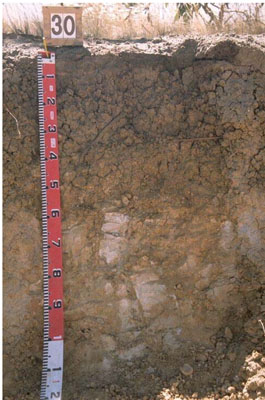 Eutrophic, Mesonatric, Grey Sodosol | |
|
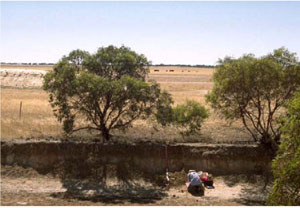
Location | Chappel Road, Telopea Downs, western Victoria | |||
|
Landform | Gently undulating plains | |||
|
Geology | Quaternary Woorinen Formation: aeolian dune sand, calcareous clay | |||
|
Element | Swale/depression | |||
Horizon | Depth (cm) | Description | ||
A1 | 0–10 | Dark greyish brown (10YR4/2); organic sandy loam; weak medium subangular blocky structure; firm consistence (dry); pH 6.7. | ||
B21 | 10–30 | Greyish brown (10YR5/2) with common faint brownish yellow mottles; medium clay; strong fine polyhedral structure; strong consistence (dry); pH 7.2. | ||
B22 | 30–50 | Brownish yellow (10YR6/6) with few distinct orange mottles; medium heavy clay; strong medium and coarse polyhedral structure; pH 8.7. | ||
C | 50–100+ | Pale mottled sandy material. | ||
| Management considerations | ||||
| ||||
Site WW30 | Sample depth cm | pH | EC dS/m | NaCl % | Ex Ca cmol-/kg | Ex Mg cmol-/kg | Ex K cmol-/kg | Ex Na cmol-/kg | Ex Al mg/kg | Ex acidity cmol-/kg | FC -30okPa | PWP -1500okPa | KS % | FS % | Z % | C % | |
Horizon | H2O | CaCl2 | |||||||||||||||
A1 | 0–10 | 6.7 | 5.8 | 0.16 | 4.2 | 4.8 | 0.9 | 0.9 | 0.3 | NA | NA | NA | NA | 36.4 | 32.5 | 3.5 | 21 |
B21 | 10–30 | 7.2 | 6.5 | 0.53 | 0.12 | 6.8 | 13 | 0.6 | 4.6 | NA | NA | NA | NA | 18.2 | 17.9 | 2 | 53.5 |
B22 | 30–50 | 8.7 | 8.2 | 1.3 | 0.26 | NA | NA | NA | NA | NA | NA | NA | NA | NA | NA | NA | NA |
C | 50–100+ | NA | NA | NA | NA | NA | NA | NA | NA | NA | NA | NA | NA | NA | NA | NA | NA |
© State of Victoria (Agriculture Victoria) 1996 - .

This work, Victorian Resources Online, is licensed under a Creative Commons Attribution 4.0 licence. You are free to re-use the work under that licence, on the condition that you credit the State of Victoria (Agriculture Victoria) as author, indicate if changes were made and comply with the other licence terms.
The licence does not apply to ‘branding’ or some ‘images or photographs’ that may be owned by third parties. We ask you to seek prior approval to use images using the VRO feedback form. Access to higher quality images can also be provided on request.
This page was last updated on .