
LSWW22
|
| LSWW22 | 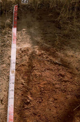 Ferric, Subnatric, Red Sodosol | |
|
Location | Harrow, western Victoria | |||
|
Landform | Rise | |||
|
Geology | Cainozoic eluvial: duricrust, ferricrete developed on various rock types | |||
|
Element | Hillslope | |||
Horizon | Depth (cm) | Description | ||
A11 | 0–30 | Brown (10YR4/3); sand (organic); massive (structureless); very weak consistence when dry; pH 5.8. | ||
Ap | 30–45 | Uncemented discontinuous nodular ferricrete and manganiferous pan; brown (7.5YR4/3); sand; massive (structureless); very weak consistence when dry; abundant ferromanganiferous nodules; pH 6.1. | ||
B21 | 45–150+ | Dusky red (2.5YR4/4); light medium clay; strong medium polyhedral, parting to strong fine subangular blocky structure; pH 6.7. | ||
| Management considerations | ||||
| ||||
Site WW22 | Sample depth cm | pH | EC dS/m | NaCl % | Ex Ca cmol-/kg | Ex Mg cmol-/kg | Ex K cmol-/kg | Ex Na cmol-/kg | Ex Al mg/kg | Ex acidity cmol-/kg | FC -30okPa | PWP -1500okPa | KS % | FS % | Z % | C % | |
Horizon | H2O | CaCl2 | |||||||||||||||
A11 | 0–30 | 5.8 | 4.7 | <0.05 | NA | NA | NA | NA | NA | NA | NA | NA | NA | NA | NA | NA | NA |
A12c | 30–45 | 6.1 | 4.8 | <0.05 | NA | NA | NA | NA | NA | NA | NA | NA | NA | NA | NA | NA | NA |
B21 | 45–150+ | 6.7 | 5.6 | 0.2 | NA | NA | NA | NA | NA | NA | NA | NA | NA | NA | NA | NA | NA |
© State of Victoria (Agriculture Victoria) 1996 - .

This work, Victorian Resources Online, is licensed under a Creative Commons Attribution 4.0 licence. You are free to re-use the work under that licence, on the condition that you credit the State of Victoria (Agriculture Victoria) as author, indicate if changes were made and comply with the other licence terms.
The licence does not apply to ‘branding’ or some ‘images or photographs’ that may be owned by third parties. We ask you to seek prior approval to use images using the VRO feedback form. Access to higher quality images can also be provided on request.
This page was last updated on .