
LSWW14
|
| LSWW14 | 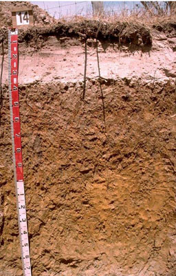 Vertic, Mottled-Mesonatric, Grey Sodosol | |
|
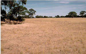
Location | North-west of Lake Wallace, Edenhope, western Victoria | |||
|
Landform | Plain | |||
|
Geology | Quaternary Lowan Formation: aeolian fine to medium grained dune sand | |||
|
Element | Plain | |||
Horizon | Depth (cm) | Description | ||
A1 | 0–10 | Very dark greyish brown (10YR3/2); sand (organic); weak consistence when dry; pH 5.8; abrupt boundary to: | ||
A2 | 10–35 | Pink (7.5YR7/4); conspicuously bleached sand;; massive (structureless); weak consistence when dry; few subrounded ferruginous nodules; pH 6.5; thin (2-5 mm) capping directly above the clay with a very strong consistence when dry; sharp boundary to: | ||
B21 | 35–70 | Pale brown (10YR6/3) changing at depth to yellowish brown (10YR5/6) with abundant coarse distinct red, light grey and yellowish brown mottles; medium clay; moderate coarse blocky, parting to moderate medium polyhedral structure and in patches strong fine polyhedral structure; strong consistence when dry (dispersive when worked); pH 6.4; clear boundary to: | ||
B22 | 70–120 | Yellowish brown (10YR5/6); medium clay; dark stains on prism faces; moderate to strong coarse prismatic, parting to moderate coarse blocky structure; strong consistence when slightly moist; pockets of clayey sand; pH 8.2; gradual boundary to: | ||
B23 | 120–150 | Yellow (10YR7/8); medium clay; strong lenticular structure in patches; firm to very firm consistence when moderately moist; pH 8.8; gradual boundary to: | ||
B31 | 150–170 | Brownish yellow (10YR6/6); sandy clay (with patches of grey); firm consistence when moderately moist; pH 8.6; gradual boundary to: | ||
B32 | 170–200+ | Pinkish grey (7.5YR6/2); sandy clay loam; veins of bluish grey (5B6/1) clay and red flecks of quartz sand; firm consistence when moderately moist; pH 8.7. | ||
| Management considerations | ||||
| ||||
Site WW14 | Sample depth cm | pH | EC dS/m | NaCl % | Ex Ca cmol-/kg | Ex Mg cmol-/kg | Ex K cmol-/kg | Ex Na cmol-/kg | Ex Al mg/kg | Ex acidity cmol-/kg | FC -30okPa | PWP -1500okPa | KS % | FS % | Z % | C % | |
Horizon | H2O | CaCl2 | |||||||||||||||
A1 | 0–10 | 5.8 | 5.1 | 0.05 | NA | 1.7 | 0.4 | 0.1 | 0.1 | NA | NA | NA | 6.1 | 53.6 | 31.1 | 4 | 5.5 |
A2 | 10–35 | 6.5 | 5.8 | <0.05 | NA | <0.1 | <0.1 | <0.1 | <0.1 | NA | NA | NA | 0.9 | 48.9 | 42.6 | 2.5 | 3 |
B21 | 35–70 | 6.4 | 5.3 | 0.09 | NA | 2.7 | 7.3 | 0.4 | 2.4 | NA | NA | NA | 23.9 | 15.2 | 12 | 2 | 64 |
B22 | 70–120 | 6.9 | 5.8 | 0.11 | NA | 2.5 | 7.2 | 0.3 | 2.5 | NA | NA | NA | 18.1 | 23.6 | 20.2 | 2 | 49.5 |
B22 | 70–120 | 8.2 | 7.6 | 0.49 | 0.11 | 2.8 | 9.4 | 0.3 | 4.6 | NA | NA | NA | NA | NA | NA | NA | NA |
B23 | 120–150 | 8.6 | 7.6 | 0.32 | 0.08 | NA | NA | NA | NA | NA | NA | NA | NA | NA | NA | NA | NA |
B31 | 150–170 | 8.8 | 8.1 | 0.66 | 0.13 | NA | NA | NA | NA | NA | NA | NA | NA | NA | NA | NA | NA |
B32 | 170–200+ | 8.6 | 7.8 | 0.58 | 0.11 | NA | NA | NA | NA | NA | NA | NA | NA | NA | NA | NA | NA |
© State of Victoria (Agriculture Victoria) 1996 - .

This work, Victorian Resources Online, is licensed under a Creative Commons Attribution 4.0 licence. You are free to re-use the work under that licence, on the condition that you credit the State of Victoria (Agriculture Victoria) as author, indicate if changes were made and comply with the other licence terms.
The licence does not apply to ‘branding’ or some ‘images or photographs’ that may be owned by third parties. We ask you to seek prior approval to use images using the VRO feedback form. Access to higher quality images can also be provided on request.
This page was last updated on .