
LSWW12
|
| LSWW12 | 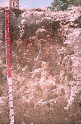 Vertic (and Calcic), Subnatric, Grey Sodosol | |
|
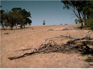
Location | West of Booroopki Swamp, western Victoria | |||
|
Landform | Rise | |||
|
Geology | Quaternary Lowan Formation: aeolian fine to medium grained dune sand | |||
|
Element | Hillslope | |||
Horizon | Depth (cm) | Description | ||
A1 | 0–15 | Very dark greyish brown (10YR3/2); sandy loam; massive (structureless); weak consistence when dry; structure increases to weak coarse blocky structure where roots penetrate; pH 6.3; sharp and wavy boundary to: | ||
A2 | 15–20 | Pale brown (10YR6/3); loamy sand; conspicuously bleached; strong consistence when dry; occurs as capping on top of columnar domes of B21; pH 6.7; sharp and wavy boundary to: | ||
B21 | 20–40 | Brown (7.5YR5/2) with many very coarse distinct red mottles; medium heavy clay; strong very coarse columnar, parting to weak very coarse blocky structure; dispersive when worked; pH 7.5; gradual boundary to: | ||
B22 | 40–60 | Yellowish red (5YR5/8); medium heavy clay; moderate coarse blocky structure; completely dispersive; pH 8.8. | ||
B23 | 60–90 | Light yellowish brown (10YR6/4); medium clay; common soft calcareous segregations; pH 9.4. | ||
B24k | 90–130 | Very pale brown (10YR7/3); light clay (sandy); moderate medium polyhedral, parting to fine polyhedral structure; many soft calcium carbonate segregations and few hard carbonate/silica nodules (5-15 mm in size); pH 9.5. | ||
B25 | 130–170+ | Light grey (2.5Y7/2); medium clay; moderate to strong lenticular structure; few slickensides; smooth ped-fabric with sand along ped faces; pH 9.5. | ||
| Management considerations | ||||
| ||||
Site WW12 | Sample depth cm | pH | EC dS/m | NaCl % | Ex Ca cmol-/kg | Ex Mg cmol-/kg | Ex K cmol-/kg | Ex Na cmol-/kg | Ex Al mg/kg | Ex acidity cmol-/kg | FC -30okPa | PWP -1500okPa | KS % | FS % | Z % | C % | |
Horizon | H2O | CaCl2 | |||||||||||||||
A1 | 0–15 | 6.3 | 6 | 0.21 | NA | 3.1 | 1.1 | 0.6 | 0.3 | NA | NA | NA | 9.6 | 33.7 | 38.4 | 8.5 | 11.5 |
A2 | 15–20 | 6.7 | 5.9 | <0.05 | NA | 1.3 | 0.4 | 0.2 | 0.1 | NA | NA | NA | 2.2 | 36.8 | 44.6 | 10 | 7.5 |
B21 | 20–40 | 7.5 | 6.6 | 0.13 | NA | 10 | 11 | 1.5 | 2 | NA | NA | NA | 23.0 | 14.6 | 22.5 | 5.5 | 50.5 |
B22 | 40–60 | 8.8 | 7.8 | 0.22 | NA | 10 | 15 | 1.5 | 4.9 | NA | NA | NA | 25.3 | 13.7 | 18 | 6 | 54.5 |
B23 | 60–90 | 9.4 | 8.8 | 0.67 | 0.1 | NA | NA | NA | NA | NA | NA | NA | NA | NA | NA | NA | NA |
B24k | 90–130 | 9.5 | 8.8 | 0.86 | 0.14 | NA | NA | NA | NA | NA | NA | NA | NA | NA | NA | NA | NA |
B25 | 130–170+ | 9.5 | 8.9 | 1.1 | 0.2 | 5.3 | 14 | 1 | 9.3 | NA | NA | NA | NA | NA | NA | NA | NA |
© State of Victoria (Agriculture Victoria) 1996 - .

This work, Victorian Resources Online, is licensed under a Creative Commons Attribution 4.0 licence. You are free to re-use the work under that licence, on the condition that you credit the State of Victoria (Agriculture Victoria) as author, indicate if changes were made and comply with the other licence terms.
The licence does not apply to ‘branding’ or some ‘images or photographs’ that may be owned by third parties. We ask you to seek prior approval to use images using the VRO feedback form. Access to higher quality images can also be provided on request.
This page was last updated on .