
LSWW10
|
| LSWW10 | 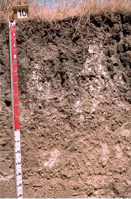 Endocalcareous-Endohypersodic, Self-mulching Grey Vertosol | |
|
Location | Minimay, western Victoria | |||
|
Landform | Plain | |||
|
Geology | Quaternary Woorinen Formation: aeolian dune sand, calcareous clay | |||
|
Element | Plain | |||
Horizon | Depth (cm) | Description | ||
A1 | 0–10 | Dark grey (10YR4/1); light clay; moderate coarse blocky structure; very firm consistence when dry; pH 7.8; clear boundary to: | ||
B21 | 10–75 | Dark grey (10YR4/1); medium clay; strong coarse blocky structure; smooth ped-fabric, strong consistence when dry; pH8.6; gradual and tongued boundary to: | ||
B22k | 75–100 | Light grey (2.5Y7/2); light medium clay; strong coarse blocky structure; very strong consistence when slightly moist; many (10-30%) soft and semi-hard calcareous segregations; pH 9.4; salinity increases to 7.7 EC | ||
B23 | 100–200+ | Light grey (2.5Y7/2) with few red mottles; medium heavy clay; prismatic, parting to strong medium polyhedral structure; patches of soft calcareous segregations and few hard calcareous and iron/carbonate/silica segregations; pH 9.4. | ||
| Management considerations | ||||
| ||||
Site WW10 | Sample depth cm | pH | EC dS/m | NaCl % | Ex Ca cmol-/kg | Ex Mg cmol-/kg | Ex K cmol-/kg | Ex Na cmol-/kg | Ex Al mg/kg | Ex acidity cmol-/kg | FC -30okPa | PWP -1500okPa | KS % | FS % | Z % | C % | |
Horizon | H2O | CaCl2 | |||||||||||||||
A1 | 0–10 | 7.8 | 7.3 | 0.21 | NA | 17.0 | 3.7 | 1.6 | 0.5 | NA | NA | NA | 20.3 | 16.8 | 28.9 | 5.0 | 38.5 |
B21 | 10–75 | 8.6 | 7.8 | 0.18 | NA | 16.0 | 6.6 | 1.5 | 1.4 | NA | NA | NA | 22.3 | 20.0 | 23.6 | 3.5 | 44.0 |
B22k | 75–100 | 9.4 | 8.6 | 1.1 | NA | NA | NA | NA | NA | NA | NA | NA | 23.2 | 16.6 | 18.6 | 4.5 | 45.0 |
B23 | 100–200+ | 9.4 | 8.6 | 1.4 | NA | 4.1 | 11.0 | 1.8 | 11.0 | NA | NA | NA | NA | NA | NA | NA | NA |
© State of Victoria (Agriculture Victoria) 1996 - .

This work, Victorian Resources Online, is licensed under a Creative Commons Attribution 4.0 licence. You are free to re-use the work under that licence, on the condition that you credit the State of Victoria (Agriculture Victoria) as author, indicate if changes were made and comply with the other licence terms.
The licence does not apply to ‘branding’ or some ‘images or photographs’ that may be owned by third parties. We ask you to seek prior approval to use images using the VRO feedback form. Access to higher quality images can also be provided on request.
This page was last updated on .