
Site WW12
Location: Lillimur
Australian Soil Classification: Vertic (and Calcic), Subnatric, Grey SODOSOL
Northcote Factual Key: Dy3.43
Great Soil Group: solodised solonetz
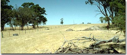 Site WW12 Landscape |
General Landscape Description: This soil type occurs on the lower slope in association with the crests (WW11) when the slope flattens out to form clay plains or drainage depressions. It is similar to WW13 and WW15. This soil type is regarded as the most appropriate to represent these land units as it is located on a long gentle slope which is a common land element in the Shire. The land tends to have gilgai micro-relief. Soil profile variability (ie. when darker pockets of soil are close to the surface) is also an indication of the gilgaied nature of the soil. The common soil type on the crests and slopes are Sodosols with a hardsetting bleached sandy surface horizon over large hardsetting clay columns or prisms (solodised solonetz). There are scattered occurrences of Ferric Sodosols (soils with an ‘ironstone’ horizon below the bleached horizon and above the clay. The small rises are commonly divided by low lying flat clay plains which support Buloke. The vegetation is a reasonable indication of the soil type. Yellow Gums tend to occur with solodised solonetz forms; Red Gums with Ferric Sodosols and Bulokes on the heavier clay soils. When this soil type occurs further south, the hardsetting columns in the top of the subsoils are more acidic.
Soil Profile Morphology:
Surface Soil
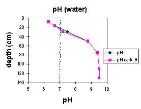
| A1 | 0-15 cm | Very dark greyish brown (10YR3/2) sandy loam; structureless; weak consistence when dry; structure increases to weak blocky structure (peds 20-50 mm) when roots penetrate; pH 6.3; sharp and wavy transition to: | 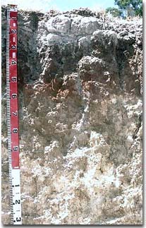 Site WW12 profile |
| A2 | 15-20 cm | Pale brown (10YR6/3) loamy sand; conspicuously bleached; strong consistence when dry; occurs as capping on top of columnar structure; pH 6.7; sharp and wavy transition to: | |
| Subsoil | |||
| B21 | 20-40 cm | Brown (7.5YR5/2) medium heavy clay; many very coarse distinct red mottles; strong columnar structure (peds >200 mm) parting to weak blocky structure (peds 50-100 mm); dispersive when worked; pH 7.5; gradual transition to: | |
| B22 | 40-60 cm | Yellowish red (5YR5/8) medium heavy clay; moderate blocky structure (peds 20-50 mm); completely dispersive; pH 8.8: | |
| B23 | 60-90 cm | Light yellowish brown (10YR6/4) medium clay; soft calcium carbonate segregations common; pH 9.4: | |
| B24k | 90-130 cm | Very pale brown (10YR7/3) light clay (sandy); moderate polyhedral structure (peds 10-20 mm parting to 5-10 mm); many soft calcium carbonate segregations and a few hard carbonate/silica nodules (5-15 mm in size); pH 9.5: | |
| B25 | 130-170+ cm | Light grey (2.5Y7/2) medium clay; moderate to strong lenticular structure with some slickensides; smooth fabric, with sand along ped faces; pH 9.5. | |
Horizon | pH | Salinity | Internal Drainage | Hydro-phobicity | ||
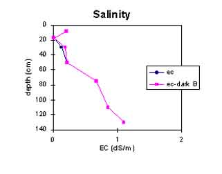
Surface (A1 horizon) | slightly acid | low | non-sodic | - | - | moderate |
Subsoil (B21 horizon) | slightly alkaline | low | sodic | slight1 | Imperfectly drained3 | - |
Deeper subsoil (at 1 metre) | very strongly alkaline | high | - | nil2 | - | - |
2 Possible due to high soluble salts (moderate dispersion after remoulding).
3 Most impeding horizon of the profile that will affect plant growth.
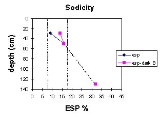
 |  |
 | 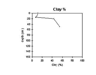 |
Key Profile Features:
- Sandy surface soil.
- Hydrophobic surface soil.
- Shallow depth of surface soil.
- Strong texture contrast between the surface soil and subsoil.
- Thin hardsetting bleached capping (A2) forming domes on top of large columns.
- Columnar subsoil structure.
- Top of the subsoil is dispersive following cultivation when wet.
- Sodic subsoil.
- Subsoil mottling.
- Alkaline subsoil.
- Soil salinity at depth.
- Vertic properties (ie. lenticular structure) in the deeper subsoil.
Feature | Result | Management Prescription |
| Sandy surface soil. |
| Dryland cropping.
|
| Hydrophobic surface soil. |
|
|
| Shallow surface soil depth. |
|
|
| Bleached A2 horizon. |
| Dryland cropping.
|
| Strong textural contrast between surface soil and subsoil (duplex). |
|
|
| Sodic clay subsoil. |
|
|
| Columnar or prismatic subsoil structure. |
|
|
| Mottled subsoil. |
|
|
| Dispersion when reworked. |
|
|
| Alkaline subsoil. |
|
|
| Soil salinity at depth. |
|
|
Land Suitability Rating Table:
LAND USE | SUITABILITY CLASS | MAJOR LIMITING COMPONENT |
| Wheat | 2 | Climate, soil |
| Canola | 2 | Climate, soil |
| Chickpeas | 3 | Soil |
| Lentils | 3 | Soil |
| White clover seed | 2 | Soil |
| Lucerne forseed production | 3 | Soil |
| Viticulture | 3 | Soil |
| Apples | 3 | Soil |
| Potatoes | 3 | Soil |
| Carrots | 3 | Soil |
| Onions | 3 | Soil |
| Sweet corn | 3 | Soil |
| Radiata Pine | 3 | Climate |
| Blue Gum | 3 | Climate |
Land Suitability Assessment and Primary Limitations:
| Wheat | Climate | 2 | Moderate frost risk, slightly high rainfall. |
| Landscape | 1 | No major limitation. | |
| Soil | 2 | Slightly impeded internal drainage, hydrophobicity. | |
| Canola | Climate | 2 | Moderate frost risk. |
| Landscape | 1 | No major limitation. | |
| Soil | 2 | Soil salinity, hydrophobicity, slightly impeded internal drainage. | |
| Chickpeas | Climate | 2* | Moderate frost risk, moderate to high rainfall. |
| Landscape | 2 | Wind erosion hazard. | |
| Soil | 3 | Impeded internal drainage. | |
| Lentils | Climate | 2 | Moderate frost risk, slightly high rainfall. |
| Landscape | 2 | Wind erosion hazard. | |
| Soil | 3 | Impeded internal drainage. | |
| White clover seed | Climate | 1 | No major limitation. |
| Landscape | 1 | No major limitation. | |
| Soil | 2 | Soil salinity, slightly impeded internal drainage, hydrophobicity. | |
| Lucerne for seed production | Climate | 1 | No major limitation. |
| Landscape | 1 | No major limitation. | |
| Soil | 3 | Soil salinity, impeded internal drainage. | |
| Viticulture | Climate | 2 | Moderate frost risk. |
| Landscape | 1 | No major limitation. | |
| Soil | 3 | Soil salinity, impeded internal drainage. | |
| Apples | Climate | 2 | Moderate frost risk, slightly high mean maximum January temperature. |
| Landscape | 1 | No major limitation. | |
| Soil | 3 | Soil salinity. | |
| Potatoes | Climate | 2 | Slightly high mean maximum January temperature. |
| Landscape | 2 | Wind erosion hazard. | |
| Soil | 3 | Shallow surface soil, impeded internal drainage. | |
| Carrots | Climate | 1 | No major limitation. |
| Landscape | 2 | Wind erosion hazard. | |
| Soil | 3 | Shallow surface soil, impeded internal drainage. | |
| Onions | Climate | 2 | Moderate frost risk. |
| Landscape | 2 | Wind erosion hazard | |
| Soil | 3 | Impeded internal drainage. | |
| Sweet corn | Climate | 2 | Slightly low mean monthly temperature (October - March). |
| Landscape | 1 | No major limitation. | |
| Soil | 3 | Impeded internal drainage. | |
| Radiata Pine | Climate | 3 | Low rainfall. |
| Landscape | 1 | No major limitations. | |
| Soil | 2 | Soil salinity, slightly impeded internal drainage. | |
| Blue Gum | Climate | 3 | Low rainfall. |
| Landscape | 1 | No major limitations. | |
| Soil | 2 | Soil salinity, slightly impeded internal drainage. |
Profile Described By: Mark Imhof, Nathalie Baxter (08/01/97).
© State of Victoria (Agriculture Victoria) 1996 - .

This work, Victorian Resources Online, is licensed under a Creative Commons Attribution 4.0 licence. You are free to re-use the work under that licence, on the condition that you credit the State of Victoria (Agriculture Victoria) as author, indicate if changes were made and comply with the other licence terms.
The licence does not apply to ‘branding’ or some ‘images or photographs’ that may be owned by third parties. We ask you to seek prior approval to use images using the VRO feedback form. Access to higher quality images can also be provided on request.
This page was last updated on .