
Site IS19
Location: Drung Drung
Australian Soil Classification: Episodic-Epicalcareous, Self-Mulching, Grey VERTOSOL
General Landscape Description: Anastomotic plain.
Geology: Quaternary Shepparton Formation: fluvial silt, sand and minor gravel.
Soil Profile Morphology:
Surface Soil
| A1 | 0-10 cm | Dark grey (10YR4/1); light clay; subplastic; cracking and self-mulching surface condition; weak subangular blocky structure; weak consistence dry; slightly sticky consistence wet; very few (<2%) hard carbonate segregations; pH 6.8; sharp and wavy boundary to: | 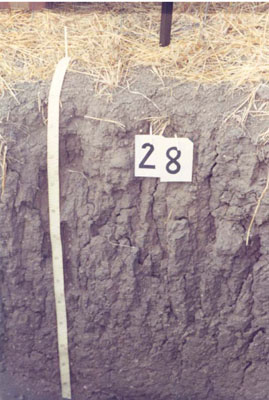 IS19 Profile |
| Subsoil | |||
| B21 | 10-25 cm | Dark grey (10YR4/1); light clay; subplastic; moderate very coarse prismatic structure; strong consistence dry; slightly sticky consistence wet; very few (<2%) hard carbonate segregations; pH 8.6. | |
| B22 | 25-60 cm | Dark grey (10YR4/1); medium heavy clay; subplastic; moderate very coarse prismatic structure; weak consistence dry; slightly sticky consistence wet; very few (<2%) hard carbonate segregations; pH 8.9; gradual and smooth boundary to: | |
| B23 | 60-90 cm | Dark grey (10YR4/1); heavy clay; plastic; coarse lenticular structure (slickensides); very few (<2%) hard carbonate segregations; pH 9.2; gradual boundary to: | |
| B31k | 90-130 cm | Greyish brown (10YR5/2); heavy clay; plastic; coarse lenticular structure (slickensides); few (2-10%) hard carbonate segregations; pH 9.3; gradual boundary to: | |
| B32 | 130-195 | Greyish brown (10YR5/2); medium clay; plastic; moderate angular blocky structure; very strong consistence dry; slightly sticky consistence wet; very few (<2%) hard carbonate segregations; pH 9.4. | |
Soil Profile Characteristics:
Horizon | Sample Depth cm | pH | EC dS/m | Sodium Chloride % | Exchangeable Calcium cmol-/kg | Exchangeable Magnesium cmol-/kg | Exchangeable Potassium cmol-/kg | Exchangeable Sodium cmol-/kg | Exchangeable Aluminium mg/kg | Exchangeable Acidity cmol-/kg | Field Capacity -30okPa | Permanent Wilting Point -1500okPa | Coarse Sand % | Fine Sand % | Silt % | Clay % | |
H2O | CaCl2 | ||||||||||||||||
A1 | 0–10 | 6.8 | NA | 0.17 | 0.02 | 2.7 | 6.9 | 0.6 | 2 | NA | 5.1 | 29.9 | 11.7 | 29 | 38 | 3 | 28 |
B21 | 10–25 | 8.6 | NA | 0.12 | 0.01 | 22.9 | 10.3 | 1.7 | 0.8 | NA | 3.6 | NA | 22.4 | 9 | 21 | 9 | 61 |
B22 | 25–60 | 8.9 | NA | 0.17 | 0.01 | 17 | 15.5 | 1.3 | 1.7 | NA | 5.3 | NA | 23.3 | 8 | 18 | 8 | 63 |
B23 | 60–90 | 9.2 | NA | 0.24 | 0.03 | 13.4 | 19.8 | 1.5 | 3.3 | NA | NA | NA | 25.5 | 7 | 17 | 9 | 64 |
B31k | 90–130 | 9.3 | NA | 0.33 | 0.02 | 11.5 | 20.8 | 1.5 | 5.4 | NA | NA | NA | 26.7 | 8 | 15 | 9 | 65 |
B32 | 130–195 | 9.4 | NA | 0.44 | 0.02 | NA | NA | NA | NA | NA | NA | NA | 28.5 | 4 | 13 | 10 | 68 |
Management Considerations:
- Cracking clay profile, possible texture contrast.
- Sodic surface, possible surface sealing/impeded infiltration despite self mulching characteristic.
- High fine sand content of surface (possible windblown inclusions).
- High calcium levels in upper subsoil, high magnesium levels in lower subsoil.
- Sodic subsoil below 60 cm, increasing with depth.
- Landform element, plain; slow site drainage, unless near drainage line.
Profile Described By: John Martin, Nabil Badawy, Ron Cawood, Geoff Pope, John Galea, John Turner (1970).
© State of Victoria (Agriculture Victoria) 1996 - .

This work, Victorian Resources Online, is licensed under a Creative Commons Attribution 4.0 licence. You are free to re-use the work under that licence, on the condition that you credit the State of Victoria (Agriculture Victoria) as author, indicate if changes were made and comply with the other licence terms.
The licence does not apply to ‘branding’ or some ‘images or photographs’ that may be owned by third parties. We ask you to seek prior approval to use images using the VRO feedback form. Access to higher quality images can also be provided on request.
This page was last updated on .