
Gypsum Prospectivity
Investing in the Wimmera Minerals and Energy
The following information has been prepared from material in the Geological Survey of Victoria Technical Record 1999/1 (‘Gypsum Prospectivity in Northwestern Victoria) by Avi Olshina.
| The following material has been obtained from a report from the Geological Survey of Victoria (GSV) entitled Gypsum Prospectivity in Northwestern Victoria by Avi Olshina. Gypsum mining is a substantial industry in Victoria, with production valued between $1 million and $4 million per year, depending on tonnage mined and price. Production over the last two years has been around 500 000 tonnes annually, a significant increase over that of previous years. The bulk of the gypsum is used for agricultural purposes, to treat a soil condition known as sodicity. Such treatment has been estimated to increase yield in Victoria’s wheat belt by $180 million annually (Hamilton, 1995). Gypsum has also been identified as a commodity of high potential and significant markets, a high degree of prospectivity and a prime exploration target in Victoria (McHaffie and Buckley, 1995). |  |
| Most of Victoria’s gypsum is mined in northwestern Victoria, in the area approximately west of Kerang and north of Horsham. This large area contains favourable locations for the precipitation of crystalline gypsum from saline groundwater, and transported (aeolian) gypsum (‘copi’ or ‘kopi’) incorporated within source-bordering dunes associated with the areas of primary deposition. The prospectivity of gypsum in the region has been classified by Geological Survey of Victoria (GSV) using historical and current operations; geological and soil mapping; geomorphological features; groundwater chemistry; hydrogeological information and remote sensing data. A classification system comprising four levels of prospectivity is presented as a map covering northwestern Victoria. | 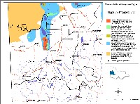 Gypsum Prospectivity in the Wimmera Catchment Management Region |
In the Wimmera region the most prospective area for gypsum is in the Wimmera River Valley and Lake Hindmarsh and Albacutya areas. This is an area roughly corresponding to the gypsum flats to the west of the Wimmera River north of Dimboola, the extensive lunettes developed to the east of lakes Hindmarsh and Albacutya, and two areas of gypsum flats north and northeast of Lake Albacutya (the former of which lies within the boundaries of the Wyperfeld National Park). This area also includes a region of known gypsum occurrence around and to the east of Yanac Swamp and another to the west of Lake Hindmarsh, near Perenna. All the above probably represent either modern or recent areas of groundwater discharge and aeolian (lunette) accumulations. The area of high prospectivity in this region totals about 620 km2.
Gypsum is an important natural resource found associated with modern or geologically recent groundwater discharge areas in northwestern Victoria. The prospectivity of the region has been classified by Geological Survey of Victoria using historical and current operations, geological and soil mapping, geomorphological features, groundwater chemistry, hydrogeological information and remote sensing data. A classification system comprising four levels of prospectivity is presented as a map covering the northern Wimmera region.
The most prospective areas for gypsum deposits incorporate the following features:
- brackish to saline groundwater saturated in CaSO4;
- water table within about 2 m of ground surface (either currently or within the recent past);
- high evaporative potential;
- low rainfall;
- large temperature differences between summer and winter; and
- areas of internal drainage
- Areas of highest prospectivity. These were associated with known deposits worked either in the past or at present, areas mapped as containing gypsum (Yamba Formation) and the associated landforms, including lakebeds and associated copi-bearing lunettes.
- Areas of high prospectivity as determined by proximity to known occurrences, similar landforms to those of nearby known occurrences and associated shallow watertables with saline groundwater containing high [Ca++]*[SO4--] solubility product.
- Prospective areas as defined by generally favourable geochemical and hydrogeological conditions and remote sensing (LANDSAT) characteristics similar to those of areas of confirmed gypsum occurrence.
- Broadly prospective areas approximating regional direct groundwater discharge features (both modern and ancient) and broadly supported by favourable hydrogeological and hydrogeochemical evidence.
Gypsum Formation
Major factors in the precipitation of gypsum from groundwater include groundwater saturated in CaSO4, high evaporation rates and near-surface water tables. The very flat topography of the area, combined with insignificant rates of denudation (other than by wind) acts to preserve deposits from erosion.
Crystalline gypsum may be found on lake beds, encrusting rocks, branches, etc., and within lake-bed sediments as fine to coarse disseminated gypsum (‘sugar’ gypsum) or as large euhedral crystals and crystal clusters up to around 10 cm in length. The crystal form may be affected by the pH of the groundwater, with large prismatic crystals tending to occur in association with low pH waters (Macumber, 1983). In some areas the gypsum forms near-continuous masses up to about 1 m thick. Often areas of copi and sugar gypsum on playas are underlain by layers of crystalline gypsum below the fine-grained surface material (Lawrence, 1971). Fine, powdery copi is probably derived from the break-up of coarser crystalline gypsum, or as a result of relatively rapid, precipitation of gypsum from groundwater, resulting in small grain size.
Gypsum crystals from sub-surface accumulations tend to have considerably higher proportions of inclusions (apparently matrix sand and mud) than crystals precipitating directly from clear lake water.
References
Abbott, S. B., 1914. Some gypsum deposits of Victoria. Geological Survey of Victoria Unpublished Report 1914/6.
Hamilton, G., 1995. A strategic review of the Victorian gypsum industry. Department of Agriculture, Energy and Minerals (unpubl.).
Lawrence, C. R., 1971. Occurrence and production of halite and gypsum in Victoria. In N. H. Campbell (ed) Mining and Geological Journal 7 (1). Department of Mines, Victoria. pp 17 - 19.
McHaffie, I.W., & Buckley, R., 1995. Industrial minerals and rocks of Victoria. Geological Survey of Victoria Report 102.
MaCumber, P. G., 1983. Interactions between groundwater and surface systems in northern Victoria. Unpublished Ph.D. thesis, Department of Geology, University of Melbourne.
MaCumber, P. G., 1991. Interaction between groundwater and surface systems in northern Victoria. Department of Conservation and Environment, Victoria. 345 p.
Thomas, D. E., 1947. Some gypsum deposits of Victoria. In D. C. Swift (ed.). Mining and Geological Journal 3 (2). Department of Mines, Victoria. pp 23-24.
© State of Victoria (Agriculture Victoria) 1996 - .

This work, Victorian Resources Online, is licensed under a Creative Commons Attribution 4.0 licence. You are free to re-use the work under that licence, on the condition that you credit the State of Victoria (Agriculture Victoria) as author, indicate if changes were made and comply with the other licence terms.
The licence does not apply to ‘branding’ or some ‘images or photographs’ that may be owned by third parties. We ask you to seek prior approval to use images using the VRO feedback form. Access to higher quality images can also be provided on request.
This page was last updated on .