
Monomeith (Mn)
| Geology Recent alluvium. Landform Alluvial plain. | 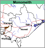 |
This soil is equivalent to the "Swamp Fringe Type" as mapped by Goudie (1942). The boundary between this and the swamp types is often difficult to distinguish. This particularly applies to the area delineated "with sandy rises" which represents the margin of the old swamp and was not waterlogged intensely enough to permit the accumulation of much peat. Here the surface soils are often medium clays.
This soil type occurs on the extensive plains south-west of the former swamp and is largely derived from sediments from the Lang Lang River and other creeks flowing from the eastern part of Westernport Bay Catchment such as Yanathan, Musk and Heifer Creeks.
The plains are traversed by old and defunct meandering stream courses generally with pronounced levees which have lighter textured surface soils. Apart from the levees which have lighter textured surface soils, most of the soils are grey or brownish grey clay loams or light clays. At about 200 mm to 300 mm they overlay grey, slightly mottled with yellow-brown, medium clay. These clays continue to at least 1500 mm. A typical example of the soil in the Monomeith map unit is pit site GP54.
Typical Profile of the Monomeith Clay Loam
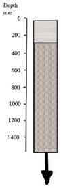 | 0 - 250 mm. Brownish grey or grey clay loam or light clay, clear transition to: 400 mm continuing. Grey with yellow-brown mottles medium to heavy clay. |
The soils mainly carry improved pasture grazed by cattle. In wet winters, stock may pug the soils quite badly. This will leave a very hard and uneven surface in summer.
Monomeith with sandy rises (Mn/sr)
Areas on the soil map inscribed with 'sr' (i.e. with sandy rises) indicate that about 20% of the area is comprised of gravelly to sandy soils as described under 'sandy rises'.
© State of Victoria (Agriculture Victoria) 1996 - .

This work, Victorian Resources Online, is licensed under a Creative Commons Attribution 4.0 licence. You are free to re-use the work under that licence, on the condition that you credit the State of Victoria (Agriculture Victoria) as author, indicate if changes were made and comply with the other licence terms.
The licence does not apply to ‘branding’ or some ‘images or photographs’ that may be owned by third parties. We ask you to seek prior approval to use images using the VRO feedback form. Access to higher quality images can also be provided on request.
This page was last updated on .