
Sandy Rises (sr)
Sandy ridges are the remnants of the beds and levees of streams that flowed from the eastern highlands. Areas on the soil map delineated "with sandy ridges" indicate that more than 20% of the area is comprised mostly of gravelly to sandy soils. The complex distribution of such sandy ridges in an area near Koo-Wee-Rup is shown in an air photo.
Ridges of sand and gravel have also accumulated on the eastern side of former swamps as a result of prevailing winds and wave action. These are also referred to as 'lunettes'. Such ridges occur near Cardinia and Rythdale and have been included within the "sandy ridges" unit. A lunette on the eastern side of an old lake bed east of Cardinia is shown in an air photo.
The sand and gravel throughout the soil profile is quite angular. The sand fraction may contain variable proportions of fine sand, coarse sand or gravel. In general, coarse sand and gravel predominates in the north-east and fine sand in the south-west. This is because the coarser fraction tended to be deposited closer to the sand source.
The surface soil of the sandy ridges ranges from grey loamy sand or gravel to sandy or gravelly peaty clay. Below about 300 mm, a layer of paler grey clayey sand to gravel occurs which may vary greatly in thickness. Mottled pale grey, yellow-brown and red-brown sandy or gravelly clays occur in the deep subsoil, generally deeper than 1.0 m.
Typical Profile of Garfield Sandy Clay Loam
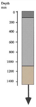 | 0 - 10 cm. Grey loamy sand or sandy loam, clear transition to: 10 - 110 cm approx. Pale grey loamy sand or gravel, clear transition to: 110 cm continuing. Pale grey mottled with yellow-brown clayey sand passing to sandy clay. |
The soils of the sandy ridges have low water-holding capacity. Pastures and crops grown on this type tend to dry off earlier in summer but in wet years they may be more productive.
© State of Victoria (Agriculture Victoria) 1996 - .

This work, Victorian Resources Online, is licensed under a Creative Commons Attribution 4.0 licence. You are free to re-use the work under that licence, on the condition that you credit the State of Victoria (Agriculture Victoria) as author, indicate if changes were made and comply with the other licence terms.
The licence does not apply to ‘branding’ or some ‘images or photographs’ that may be owned by third parties. We ask you to seek prior approval to use images using the VRO feedback form. Access to higher quality images can also be provided on request.
This page was last updated on .