
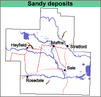
Sandy Depression (sdp)
|
Geology | 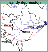 |
 |
Stream channel and associated terraces.
Original Vegetation
The original vegetation was a grassy open forest of red gum (Eucalyptus tereticornis). It has now largely been cleared.
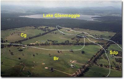 This photo shows the pattern of remaining vegetation. |
Previous Maps and Reports
Skene and Walbran (1948) mapped much of this area as Type A.
Soils
The surface soils are greyish brown gravelly sands to sandy loams overlying a bleached (light brownish grey to light brown) sand or gravelly sand. Mottled brown, yellow and grey sandy and gravelly clays occur abruptly at about 40 cm. These are underlain by variable strata of sand, clay and gravel. The soils are generally classified as Tenosols using the Australian Soil Classification.
Chemical and Physical Analysis
One soil was analysed by Skene and Walbran (1948) and is described below.
Type A, (Skene and Walbran, 1948).
Depth cm | Texture | pH | EC dS/m | Cl % | Nitrogen % | Carbon % | Gravel % | Coarse sand % | Fine sand % | Silt % | Clay % | LAT % |
0-8 | S | 6.0 | 0.07 | .007 | 0.109 | 1.59 | 39 | 42 | 11 | 5 | 1 | |
8-18 | S | 6.2 | 0.05 | .005 | 4 | 36 | 44 | 13 | 5 | <1 | ||
18-25 | S | 6.5 | 0.05 | .006 | 6 | 36 | 44 | 12 | 4 | 2 | ||
25-38 | S | 6.6 | 0.04 | .005 | 11 | 35 | 46 | 13 | 5 | <1 | ||
38-58 | GR&S | 7.4 | 0.06 | .006 | 33 | 47 | 28 | 11 | 14 | 1 | ||
58-71 | SCL | 7.9 | 0.09 | .010 | 7 | 59 | 20 | 2 | 19 | 1 | ||
76-89 | SC&S | 8.0 | 0.11 | .012 | 19 | 64 | 12 | 1 | 21 | 1 | ||
97-122 | CSC | 8.1 | 0.14 | .015 | 25 | 65 | 8 | 3 | 21 | 2 | ||
122-137 | CLS | 7.9 | 0.13 | .013 | 4 | 55 | 28 | <1 | 14 | <1 | ||
137-198 | LC | 8.3 | 0.29 | .034 | 15 | 37 | 21 | 25 | 1 |
Particle size distribution data given for Skene and Walbran (1948, 1949) does not include the water content of the soil. As a result the coarse sand, fine sand, silt, clay and loss on acid treatment (LAT) may not add up to 100%.
Other symbols include: pH - analysed in water; EC - electrical conductivity; Cl - chloride; Ca - exchangeable calcium; Mg - exchangeable magnesium, K - exchangeable potassium; Na - exchangeable sodium; H - exchangeable hydrogen; ESP - exchangeable sodium percentage.
Land Use
The land uses are similar to those of the surrounding area.
| Sandy Depression with Winnindoo (sdp/Wi) This map unit is comprised of mainly sandy depression soils with less than 30% of the Winnindoo map unit. It is confined to a broad undulating depression 2 to 4 km east of Heyfield. Most of the surface soils are quite sandy to about 40 cm but some (Winnindoo) have sandy clay loam surfaces. The textures of the subsoils are all sandy clays or heavier. | 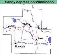 |
© State of Victoria (Agriculture Victoria) 1996 - 2025.

This work, Victorian Resources Online, is licensed under a Creative Commons Attribution 4.0 licence. You are free to re-use the work under that licence, on the condition that you credit the State of Victoria (Agriculture Victoria) as author, indicate if changes were made and comply with the other licence terms.
The licence does not apply to ‘branding’ or some ‘images or photographs’ that may be owned by third parties. We ask you to seek prior approval to use images using the VRO feedback form. Access to higher quality images can also be provided on request.
This page was last updated on 25/01/2019.