
Riverine (riv)
|
Geology | 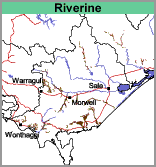 | 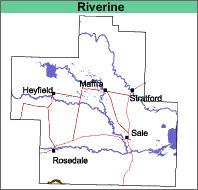 |
| Original Vegetation The original vegetation was cleared as the land is highly prized for summer grazing. This image shows the floodplain and terraces of Merriman's Creek. The floodplain is part of the Riverine map unit and the terraces form part of the Merriman's Creek map unit. Soils As the soil deposits are geologically recent, they show little soil profile development. The surface soils of this unit are all very dark grey to dark greyish brown and usually clay loams to very fine sandy or silty loams. At about 60 cm there is generally a weak increase in texture. Colours are generally mottled light brownish grey and yellowish brown. The soils tend to be Hydrosols (according to the Australian Soil Classification) and are generally saturated for a number of months in most years. Soil Site GP50 is an example of a Hydrosol on the Tarra River flats. In some cases, the profiles can be quite clayey throughout e.g. recent deposits from Jack River. Soil Site GP40 is an example of a Vertosol near Jack River. | 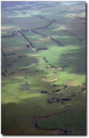 Overlooking the Tarra River near Yarram - an example of a Riverine mapping unit. |
| Chemical and Physical Analysis No analyses have been carried out on these soils. Occurrence Most of the alluvial valleys have been included in this mapping unit. Land Use Grazing of sheep and cattle is generally carried out on this map unit. | 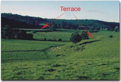 Terrace and present floodplain of Merrimans Creek. |
© State of Victoria (Agriculture Victoria) 1996 - .

This work, Victorian Resources Online, is licensed under a Creative Commons Attribution 4.0 licence. You are free to re-use the work under that licence, on the condition that you credit the State of Victoria (Agriculture Victoria) as author, indicate if changes were made and comply with the other licence terms.
The licence does not apply to ‘branding’ or some ‘images or photographs’ that may be owned by third parties. We ask you to seek prior approval to use images using the VRO feedback form. Access to higher quality images can also be provided on request.
This page was last updated on .