
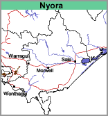
Nyora (Ny)
 |
Geology Pleistocene to Recent aeolian sediments, generally derived from and overlying Tertiary gravels, sands and clays. Landform Rolling low hills. |
Soils
Most of the soils of the Nyora map unit have grey or dark grey loamy fine sand or loamy sand surfaces with low to moderate amounts of organic matter. A pronounced bleached zone occurs at about 30 cm and from about 90 cm a ‘coffee rock’ layer is generally encountered. This layer, comprising dark brown mottled with light grey and light yellow-brown cemented sands, is generally impenetrable to the soil auger. Below the coffee rock, paler-coloured and mottled sands overlying Tertiary sediments generally occur. Although in lower areas there may be mottled clays or sandy clays.
Soil Site GP56, a brown Kurosol (with a thick sandy surface horizon), is an example of a shallow version of a soil typical of the Nyora map unit. Most of the soils, however, are Podosols.
| Land Use Originally the area was low open woodland of messmate and manna gum, with prickly tea tree, banksia, bracken, heath and grass-tree. Frequently, the vegetation form is best described as a low shrubland with emergent manna gum and messmate. Large uncleared areas of this map unit occur on French Island. These soils are infertile and require trace elements as well as superphosphate and potash in order to grow good pasture. It is only comparatively recently that pasture establishment has been successful, and large areas of this association still remain uncleared. Increasing areas are being planted to vegetables. | 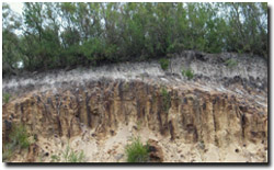 Podosol on the Nyora mapping unit |
© State of Victoria (Agriculture Victoria) 1996 - .

This work, Victorian Resources Online, is licensed under a Creative Commons Attribution 4.0 licence. You are free to re-use the work under that licence, on the condition that you credit the State of Victoria (Agriculture Victoria) as author, indicate if changes were made and comply with the other licence terms.
The licence does not apply to ‘branding’ or some ‘images or photographs’ that may be owned by third parties. We ask you to seek prior approval to use images using the VRO feedback form. Access to higher quality images can also be provided on request.
This page was last updated on .