
4. Tidal Entrances and Tidal Deltas
|
This information has been developed from the publications:
|
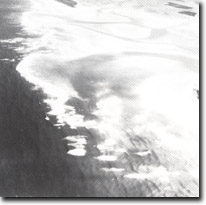
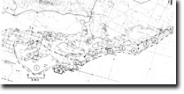
| Location: | 710120 (Port Albert Entrance) 785170 (Kate Kearney Entrance) 850190 (Shallow Inlet) 895233 (New Entrance). | 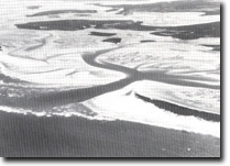 Kate Kearney Entrance and broad flood-tide delta - Shallow Inlet. |
Access: | The New Entrance may be reached by four-wheel drive vehicle from Reeves Beach and, as with Shallow Inlet, by boat from Manns Beach or McLoughlans Beach. Because of the shallowness of the channel, boat access to Kate Kearney Entrance is difficult. The Port Albert Entrance is accessible by boat from Port Albert. | |
Ownership: | Crown Land. | |
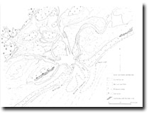
Geology/Geomorphology: 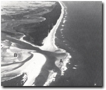 'New Entrance', lagoon and outer barrier - McLoughlans Beach to Reeve Beach. Ebb delta, (A), Flood delta, (B). | There are four tidal drainage systems east of Corner Inlet that open to Bass Strait through relatively shallow and sand encumbered inlets. The patterns of the tidal channels are determined partly by the position of the larger islands (Sunday Island, St. Margaret Island), partly by the extension of mainland streams, and partly by the slope and composition of the tidal flats. Where the tidal systems join the open sea through an inlet in the outer barrier, there are well developed double tidal deltas landward and seaward of the inlet throat. The ebb tide delta- which lies seaward of the inlet – consists of a defined central channel or deep that carries the bulk of the ebb flow and terminates as a shallowing sand lobe where the ebb jet diminishes to allow substantial deposition. The ebb current is deflected by longshore drift and the direction of spit growth and channel migration is therefore variable. Flood tide deltas are the fan shaped sand bodies that splay into the inlet. Their form is largely determined by interaction of ebb and flood currents and is less influenced by swell and wave conditions than are the ebb deltas. Ebb and flood tidal delta systems are present on all four inlets east of Corner Inlet. Of particular interest is the changing pattern of sand lobes and channels of the deltas as these indicate the complexity of tidal current flow and provide major sites for the study of sand genesis in these mesotidal inlets. The New Entrance south-west of McLoughlans Beach is of special interest as it clearly demonstrates one mode of entrance formation. Meandering of the main tidal channel south of St. Margaret Island caused erosion of the inner edge of the outer barrier and the barrier was ultimately breached by storm waves in June 1961. A tidal entrance has been maintained here and a small ebb and flood delta system is forming. Long curving spits flank the entrances to all the inlets. These are essentially barrier spits as they are part of the progradation process of the outer barrier. The most spectacular spits are those adjacent to Port Albert Entrance and Shallow Inlet. | |
Significance: | National. The tidal channels, inlets and deltas comprise a critical part of the entire barrier system and provide a classic illustration of such forms and processes in a mesotidal environment. | |
Management: | It is stressed that these are rapidly changing geomorphological features and a major aspect of their significance lies in the monitoring and interpretation of the rates and processes of this change. Engineering structures or other activities that interrupt the tidal, wave, and sediment movement patterns to the extent that the configuration and dynamics of these entrance systems would be altered should be prohibited. | |
References: | Jenkin, J.J. 1968. The geomorphology and upper Cainozoic geology of south-east Gippsland, Victoria. Mem. geol. Surv. Vict., 27. Davis, R.A. (Ed.), (1978): Coastal Sedimentary Environments. Springer - Verlag, Heidelberg, Berlin. | |
 Complex channel and shoal system - Kate Kearney Entrance (1981). | 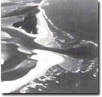 Recurving spits and tidal deltas, Shallow Inlet entrance, and 'New Entrance'. |
© State of Victoria (Agriculture Victoria) 1996 - .

This work, Victorian Resources Online, is licensed under a Creative Commons Attribution 4.0 licence. You are free to re-use the work under that licence, on the condition that you credit the State of Victoria (Agriculture Victoria) as author, indicate if changes were made and comply with the other licence terms.
The licence does not apply to ‘branding’ or some ‘images or photographs’ that may be owned by third parties. We ask you to seek prior approval to use images using the VRO feedback form. Access to higher quality images can also be provided on request.
This page was last updated on .