
Geology of Southern Gippsland
A Brief Description of the Geology of the South Gippsland Area
The oldest outcropping rocks in the South Gippsland area are of Cambrian age (approx. 580 - 500 million years old). During the Cambrian period, Victoria was covered by mainly deep ocean and populated by marine life such as trilobites. The sediments deposited during this period included fine-grained greenstone formed from submarine lava flows. Present day outcrops of greenstone material can be found along the south-western coastline of Waratah Bay.
South Gippsland remained under deep ocean throughout the Ordovician, Silurian and early Devonian periods (i.e. up to approx. 380 million years ago). At this time, Australia was part of a much larger continent (Gondwana) and did not lie in its present position. It is estimated that during the Ordovician period, for instance, Victoria was located within 20 degrees of the Equator. During the Silurian it moved southward and by the early Devonian period had moved close to its present position. Throughout these periods, thousands of metres of sediment (mainly sandstones, mudstones and shales) were laid down within a deep oceanic trough which extended from Tasmania into New South Wales. Outcrops of Devonian rocks (formed between 410 - 360 million years ago) can be found today on the Liptrap Peninsula and around Foster.
In the Silurian period primitive plant life had evolved on land. By the late Devonian period amphibians and insects had evolved as well as primitive leafy plants and ferns. From the middle Devonian period to the beginning of the Cretaceous period (a span of some two hundred and fifty million years) most of Victoria was no longer covered by ocean and several thousands of metres of sediments were eroded away forming a nearly level plain. This erosion exposed granites around Wilson's Promontory which were formed in the middle Devonian period (385 - 400 million years ago) as intruded magmatic material crystallised slowly at depth. During the late Carboniferous and Permian periods, Victoria was positioned closer to the south pole and was largely covered by glaciers. No evidence of glacial deposits has been found, however, in South Gippsland.
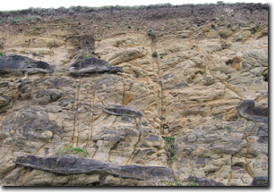
Cretaceous sediments in road cutting
In the late Jurassic and early Cretaceous periods (160-96 m.y.a), Australia and Antarctica began to split apart. As they moved apart a large basin (or 'rift valley') was formed by subsidence. This basin was then slowly filled by up to 3 000 metres of Early Cretaceous sediments (sandstones and mudstones) which were deposited by rivers and lakes. Accumulated swamp material would later be compacted to form the coal seams in the Wonthaggi area. During this period the vegetation was dominated by conifers and ferns and dinosaurs were common. A number of important fossils from this period have been found near Koonwarra.
From the Middle Cretaceous period, Australia moved further away from Antarctica. The stresses caused by this separation resulted in significant folding, faulting and uplifting of the Early Cretaceous basin sediments. The uplift resulted in the development of the Otway and Strzelecki Ranges. The rocks forming these ranges have a high feldspar content and weather relatively easily. This (together with the high rainfall) has resulted in the development of rounded hills with generally deep soils.
During the upper Cretaceous and early Tertiary periods, extensive lava flows occurred within many of the valleys in South Gippsland. Extensive present day outcrops are located in uplifted areas of the South Gippsland Highlands (north of Mirboo), around the eastern margin of the ranges and around Leongatha and Dumbalk. In other areas they have been covered by subsequent Tertiary and Quaternary sediments (e.g. in Lang Lang River basin).
Victoria experienced a warm and wet climate throughout much of the Tertiary period and temperate rainforest was widespread over the state. During the Tertiary period (from approximately 65 million years ago) Australia continued to drift away from Antarctica (at rates of up to 6 cm per year). Three interconnected basins (Otway, Gippsland and Bass) formed along the southern edge of Victoria's continental plate and significant marine sediments were laid down in shallow seas. Some parts of these basins now lie onshore but most are to be found beneath Bass Strait. The sea level fluctuated significantly during Tertiary times.
Following the uplift of the South-Eastern Highlands in the Tertiary period (approximately 5 million years ago), extensive river systems developed over dry land areas. These rivers developed deep channels, which were filled with coarse gravels. Some of these have been preserved as river terraces along present-day streams. As the uplands became more and more eroded, the rivers draining them became much reduced. These slower flowing streams then deposited only fine grained sediments such as silt. As a result the coarser gravels were covered by finer-grained sediments.
The most recent geological period is the Quaternary which extended from 1.6 million years ago to recent times. During the Quaternary there were several ice ages which resulted in significant sea-level changes. The most recent ice age peaked at approximately 25 000 years ago and sea levels were some 150 m lower than present. Quaternary deposits include:
- Coastal deposits such as dunes, beach deposits, windblown sand sheets and barrier deposits.
- Swamp and lagoonal deposits.
- Stream alluvium (sands, silts and clays deposited by streams carrying eroded material from the highlands).
References
Cochrane, G.W., Quick, G.W. and Spencer-Jones, D. (Eds), (1991). Introducing Victorian Geology. Victn. Div. Geol. Soc. Aust. pp. 320.
Land Conservation Council (1980). Report on the South Gippsland Area, District 2
Costermans, L. (1983) Native trees and shrubs of South-Eastern Australia. Lansdowne Pub. Pty Ltd.
© State of Victoria (Agriculture Victoria) 1996 - .

This work, Victorian Resources Online, is licensed under a Creative Commons Attribution 4.0 licence. You are free to re-use the work under that licence, on the condition that you credit the State of Victoria (Agriculture Victoria) as author, indicate if changes were made and comply with the other licence terms.
The licence does not apply to ‘branding’ or some ‘images or photographs’ that may be owned by third parties. We ask you to seek prior approval to use images using the VRO feedback form. Access to higher quality images can also be provided on request.
This page was last updated on .