
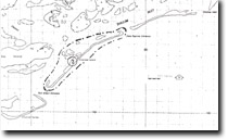
2. Clonmel Island
|
This information has been developed from the publications:
|
| Location: | 715122 to 780170. Five kilometres south of Port Albert. | |
| Access: | Boat from Port Albert. | |
Ownership: | Crown Land. | |
Geology/Geomorphology: | Clonmel Island is a barrier island nine kilometres long. It consists of two vegetated dune segments separated by a narrow high tide washover and flanked by barrier beaches that extend north-east and south-east. These culminate as recurving spits at the Port Albert Entrance and Kate Kearney Entrance. Behind the barrier beaches is a wide inter-tidal flat of sand and shell which displays a changing array of bedforms – typically small evenly spaced ripples. The configuration of the island is constantly changing due to erosion and deposition by waves and tidal currents and to vegetation colonisation of sand hummocks and berms. | |
Significance: | National. Clonmel Island, together with the Clonmel Banks to the south-west are classic examples of modes of barrier island formation as they illustrate both erosional and aggregational phases of small barrier history. Maps and charts dating from the mid-nineteenth century and at least five series of vertical aerial photographs taken since 1941 are available to allow measurement of the nature and rates of change of the barrier island to be made. This, coupled with on-going studies of sediment dynamics allows for better understanding of the origin of the Ninety Mile Beach barriers that extend to the north-east from here. | |
Management: | Dredging, dumping of dredge spoil, jetty constuction, or any other activity on or adjacent to the island that could alter the existing wave and sediment transport patters would greatly reduce the value of the site and should be prohibited. | |
© State of Victoria (Agriculture Victoria) 1996 - .

This work, Victorian Resources Online, is licensed under a Creative Commons Attribution 4.0 licence. You are free to re-use the work under that licence, on the condition that you credit the State of Victoria (Agriculture Victoria) as author, indicate if changes were made and comply with the other licence terms.
The licence does not apply to ‘branding’ or some ‘images or photographs’ that may be owned by third parties. We ask you to seek prior approval to use images using the VRO feedback form. Access to higher quality images can also be provided on request.
This page was last updated on .