
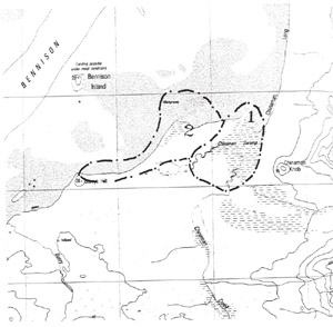
2. Barrys Hills to Bennison Point
This information has been developed from the publication:
|
| Location | 455982 to 470995. Coast south of Bennison Island. (Bennison Point is an informal name and applies to the sandy spit 1.3 km of Chinaman Creek, Wilsons Promontory National Park). | 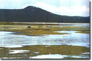 Mangrove marsh islands north of Bennison Point |
Access: | Boat access only. | |
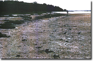
Significant Features: | This coastal sector, 2 km long, includes several significant features. At Barrys Hill, weathered granite outcrops as a shore platform with low rounded projections. There is a narrow beach typical of that in large tide range environments. The upper beach (in the high tide range) is narrow and steep (10o+) while the lower beach has a very low angle. Extending north from Barrys Hill are sandy ridges and beaches in front of an eroding salt marsh zone and Melaleuca. Sandy cheniers lie on the marsh and in the Melaleuca and there are rows of mangrove stumps partly covered by sand seaward of the chenier and salt marsh peat outcrops on the beach. The chenier material is a very coarse granitic sand and broken shell and is partly iron-stained and in places weakly cemented forming incipient beach rock. Further north, the chenier is up to 1.5 m high and has washover lobes extending 25 to 30 m into the salt marsh. These lobes enclose small saline ponds where salt is dying due to hypersalinity. | |
The distal end of the spit curves at about 45o to the east towards the mouth of Chinaman Creek. The several small islands that lie between the spit and Chinaman Creek are mangrove and salt marsh and are surrounded by dense masses of seagrass. Thick boggy piles of seagrass rack lie along the shoreline towards the mouth of the creek. The 1:250 000 geological map is in error as it shows these islands to be granite. There is no granite outcrop on the coast or intertidal area between Barrys Hill and Chinaman Creek. | ||
Significance Level: | Regional. This is a dynamic coast and shows evidence of recent rapid and substantial change. | |
Management Issues: | Not applicable. | |
Research & Monitoring Requirements: | The site is related to the development of Chinaman Creek delta. Research is necessary to evaluate delta growth and shoreline change. | |
Public Interpretation Possibilities: | Could be linked to Chinaman Creek delta and swamp. | |
Main References: | Vertical aerial photographs. | |
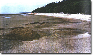 Platform in weathered granite at Barrys Hill | |
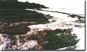 Coarse sandy chenier overwashing on saltmarsh north of Barrys Hill | 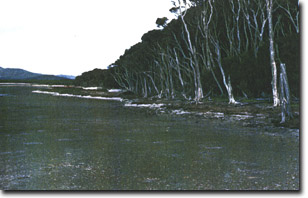 Eroding Melaleuca and peat north of Barrys Hill |
 Eroded salt marsh peat and mangrove stumps near Bennison Point north of Barrys Hill | 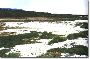 Extensive washover into salt marsh near Bennison Point near Barrys Hill |
© State of Victoria (Agriculture Victoria) 1996 - .

This work, Victorian Resources Online, is licensed under a Creative Commons Attribution 4.0 licence. You are free to re-use the work under that licence, on the condition that you credit the State of Victoria (Agriculture Victoria) as author, indicate if changes were made and comply with the other licence terms.
The licence does not apply to ‘branding’ or some ‘images or photographs’ that may be owned by third parties. We ask you to seek prior approval to use images using the VRO feedback form. Access to higher quality images can also be provided on request.
This page was last updated on .