
13. Baw Baw Plateau
This information has been developed from the publications:
|
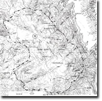
| Location: | 340170 to 430050. The Baw Baw Plateau between Mount Whitelaw and Mount Erica. | 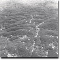 Joint-controlled drainage patterns - Baw Baw Plateau. |
Access: | Mount Erica Track, Baw Baw Alpine Village Track. | |
Ownership: | Crown Land (Baw Baw National Park). | |
Geology/Geomorphology: | The Baw Baw Plateau is developed in the Baw Baw Granodiorite and is located at an altitude between 1000 and 1563 metres. It includes a wide variety of features associated with the weathering characteristics of the granodiorite. These include broadly concave valleys, peaty flats, tors, stepped valley heads and a very distinctive rectangular drainage pattern which is controlled by the regular pattern of joints in the granodiorite. Large tors are a prominent feature of the eastern slopes of Mount Erica and also on Mount Mueller; stepped valley heads occur in Tullicoutty Glen, Whitelaw Creek and at the head of the west branch of the Tanjil River; peaty flats are prominent at Mustering Flat and the rectangular drainage is best developed between Mount Baw Baw and Mount Erica. The stepped valley forms are of particular interest as early workers attributed these to glaciation. In common with other areas of the Victorian Alps however, unequivocal supporting evidence of glaciation is lacking e.g. there are no obvious moraines or striated rocks and later research suggest that these features may be produced by weathering processes without the need for a glacial episode. | |
Significance: | National. The Australian mainland is poorly endowed with Alpine high plains and the Baw Baw Plateau is a distinctive feature of the alpine environment. It exhibits a combination of features which are only duplicated at one other site, Mount Buffalo, on the Australian mainland. | |
Management: | The inclusion of the Baw Baw Plateau in a national park has afforded the features of this important site significant protection. The exclusion of roads from the plateau and the location and maintenance of walking tracks by the National Parks Service provide sufficient protection of the features. | |
References: | Costin, A.B. 1957. Further evidence of Pleistocene glaciation in the Victorian Alps. Proc. Linn. Sic. N.S.W., 82, pp. 233-238. Talent, J.A. 1956. Siluro-Devonian brachiopods from Marble Creek, Thomson River, Victoria. Proc. R. soc. Vict., 68, pp. 73-84. | |
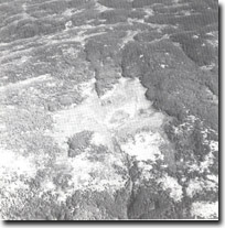 Peat swamp, Mustering Flat - Baw Baw Plateau. | 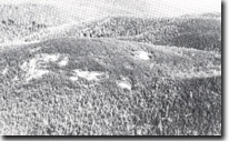 Granodiorite slopes - Mount Mueller. | 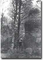 Tors on Mount Erica. |
© State of Victoria (Agriculture Victoria) 1996 - .

This work, Victorian Resources Online, is licensed under a Creative Commons Attribution 4.0 licence. You are free to re-use the work under that licence, on the condition that you credit the State of Victoria (Agriculture Victoria) as author, indicate if changes were made and comply with the other licence terms.
The licence does not apply to ‘branding’ or some ‘images or photographs’ that may be owned by third parties. We ask you to seek prior approval to use images using the VRO feedback form. Access to higher quality images can also be provided on request.
This page was last updated on .