
Geology of the Research Farm Area
The Werribee Plains are situated within a major region known as the Port Phillip Sunklands, a broad downfaulted area between the Rowsley and Selwyn Faults. The present landscape is mainly comprised of a gently undulating to level lava plain with a drainage system often influenced by old lava flows. Occasional eruption points which are higher than the surrounding plain occur throughout the region (e.g. Green Hill, One Tree Hill, Spring Hill and Mount Cottrell). Only the Werribee River, Little River and Skeleton Creek have succeeded in incising into the lava plain. The Werribee and Little Rivers have previously formed an extensive alluvial delta – leading to the development of alluvial soils suitable for cropping.
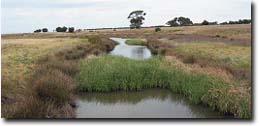 | 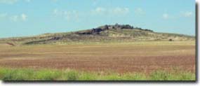 |
Present day Skeleton Creek | Mt Cottrell, near Rockbank, is one of the best examples of a lava shield volcano in Victoria |
The basalt that formed the extensive sheets of the Werribee Plains is referred to as ‘Newer Volcanics’ on geological maps and was derived from eruptions that occurred in the late Tertiary and early Quaternary times. Scoria and tuffs are rare on the Werribee Plains where the points of eruption are mostly very low and broad lava domes or small lava cones are subdued. Much of the volcanic material is dark, strongly jointed olivine basalt. Volcanoes produced abundant flows of lava that buried existing landscape features. The basaltic lava overlies a sequence of Tertiary sediments that are subdivided into the Werribee Formation (oldest) and the Fyansford Formation. These Tertiary sediments in turn overlie basement rock (either Devonian granite or Ordovician sediments).
The Rowsley fault has been a major influence on the topography of the region, and resulted in the formation of the Brisbane and Lerderderg Ranges. The most recent major movements of this fault occurred in the Early Pleistocene (approximately 1-2 million years ago). This uplift caused streams to be rejuvenated and rivers such as the Werribee River, Parwan Creek and tributaries of the Little River incised deep valleys into the uplifted plateau and the scarp of the fault. Much of this eroded material was transported down the Werribee and Little Rivers and re-deposited in the Werribee delta (Sargeant 1998).
In the Late Quaternary (Pleistocene), alluvium was laid down as a deltaic deposit in the valley of a precursor river system to the present Werribee River. This alluvium was eroded by rejuvenated streams and deposited in the Werribee River delta by a series of prior streams. In the main Werribee Irrigation District today, the present alluvial sediments may pass to coarse sands and gravels before reaching the underlying basalt at depths of over 10 metres or so (Skene 1954).
Rejuvenation of stream valleys has also taken place during several periods of sea level fall during the Pleistocene. As recently as 20 000 years ago, for instance, the sea level was over 100 metres lower than today (Jenkin 1968). This caused streams such as the Werribee River to again cut into the landscape (cutting deep into the Pleistocene alluvium). Rainfall was significantly lower (approximately half that of today) and the weather was colder and windier. Wind storms deposited aeolian sediments (ranging from sands to clays) over the region. As the sea level rose to just about its present level during the Mid Holocene (approximately 4 500 to 7 000 years ago), minor alluvial deposition also occurred in parts of the stream valleys, most notably terraces along the Werribee River (Sargeant 1998).
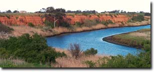
Werribee River at K Road Cliffs.
Note deep cutting into Pleistocene alluvial sediments.
References
Condon, M.A. (1951). The Geology of the Lower Werribee River, Victoria. Proc. Royal Society Victoria. Volume 63.
Geological Survey of Victoria (1974). Melbourne Sheet 1:63 360. Victorian Government Printer.
Jenkin, J.J (1968). The geomorphology and Upper Cainozoic geology of southeast Gippsland, Victoria. Mem. Geol. Surv. Vict. 27.
Maher, J.M. and Martin, J.J. (1979). Soil and Land Survey of the State Research Farm Werribee. Project Series No. 42. Department of Agriculture.
Rosengren, N.J. (1986). Sites of Geological and Geomorphological Significance in the Western region of Melbourne. Department of Conservation, Forests and Lands.
Sargeant, I.J. (1998). Geomorphology of Wyndham. Unpublished Report for Wyndham City Council.
Skene, J.K.M. (1954). Irrigated Soils of Werribee Research Farm and District. Unpublished Report. Department of Agriculture.

© State of Victoria (Agriculture Victoria) 1996 - .

This work, Victorian Resources Online, is licensed under a Creative Commons Attribution 4.0 licence. You are free to re-use the work under that licence, on the condition that you credit the State of Victoria (Agriculture Victoria) as author, indicate if changes were made and comply with the other licence terms.
The licence does not apply to ‘branding’ or some ‘images or photographs’ that may be owned by third parties. We ask you to seek prior approval to use images using the VRO feedback form. Access to higher quality images can also be provided on request.
This page was last updated on .