
79. Bungower Point - Multiple Spit
|
This information has been developed from one or more of these publications:
|
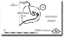
| Location: | Devon Meadows – 473656. Five hundred metres north of the Yaringa boat harbour. | 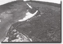 Relict curved spits (arrowed) at Bungower Point, Site 79 |
Access: | Bungower Road. | |
Ownership: | Crown Land. | |
Geology/Geomorphology: | Bungower Point is a relict multiple recurved sand spit that lies inland of a broad salt marsh and mangrove zone on the western side of Watsons Inlet. Two major episodes of recurving are present, represented by a series of low, gently curving sand ridges that enclose salt marsh deposits. The spit is now isolated from wave action by stabilising mangrove fringe. | |
Significance: | State. The spit indicates a major change in wave environments inside Westernport Bay or else a higher Holocene sea level. The spit obviously grew before the development of the mangrove and salt marsh fringe and the onset of a phase of muddy rather then sandy sedimentation. The site is therefore of major interest in the study of sea level history and sedimentation processes in Westernport Bay and on the Victorian coast in general. | |
Management: | Class 1. No further clearing, roadworks, rubbish dumping, coastal facilities or buildings of any kind should be permitted on the area of the site. | |
 Site 79, Bungower Point |

© State of Victoria (Agriculture Victoria) 1996 - .

This work, Victorian Resources Online, is licensed under a Creative Commons Attribution 4.0 licence. You are free to re-use the work under that licence, on the condition that you credit the State of Victoria (Agriculture Victoria) as author, indicate if changes were made and comply with the other licence terms.
The licence does not apply to ‘branding’ or some ‘images or photographs’ that may be owned by third parties. We ask you to seek prior approval to use images using the VRO feedback form. Access to higher quality images can also be provided on request.
This page was last updated on .