
205. Tankerton to River Point
|
This information has been developed from one or more of these publications:
|
Location: | Barrallier - 494540 to 500585. Western coast of French Island extending from 4 km north of Tankerton to near Redbill Creek. | 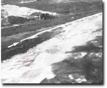 Sand spit (arrowed) extending into mangrove and saltmarsh zone width of river point. Note the absence of mangroves south of the spit and the extensive sand shoals in the intertidal zone. |
Access: | Sandy walking track leading west from the Coast Road. | |
Ownership: | Crown land. | |
Geology/Geomorphology: | North from Tankerton for approximately 7 km the coast consists of a narrow strip of sandy beach backed either by eroded salt marsh peats or undercut beach ridge deposits. North of the abandoned jetty at Fairhaven a sandy spit extends into the southern limits of the mangrove fringe. As at other sites on French Island, the presence of sandy beach sediments and eroding salt marsh deposits indicates recent removal of die-back of mangroves. In the coastal sector between Tankerton and Fairhaven, a continuous chenier has developed at the outer edge of the salt marsh deposits and this is extending northward as an active elongate sand spit or beach. This chenier is stabilised by vegetation, predominantly Atriplex, a common coloniser of sandy coastal substrates on French Island. | |
Historical changes in this section of coastline include a marked reduction in the extent of mangrove fringe, salt marsh erosion and the accumulation of drifting sand in the near shore zone (Bird and Barson 1975). It appears that the widening of gaps cut through the mangrove fringe to allow boat access, and possible removal for barilla production, initiated mangrove die-back in adjacent sectors by sandy drift from offshore sources. This has resulted in a progressive northward die-back of the mangrove fringe as the mangrove pneumatophores were smothered by large quantities of drifting sand. Present progress operating at this sensitive boundary include the growth of the sand spit which extends into the salt marsh zone behind the mangroves. Continued northward growth of the salt will further reduce the extent of mangroves along the western shoreline as their muddy substrate is covered by sandy sediments, and may result in erosion of salt marsh peats in sectors formerly protected by the mangrove fringe. The mangrove fringe is still preserved at Red Bill Creek where mangroves extend inland along tidal creeks (Site 202). | ||
Significance: | State. This is an area of rapid ecological and geomorphological change where the process of mangrove die-back related to sand drift can be studied. The entire shoreline represents an area where accurate documentation of changes in shoreline physiography is available from sources such as aerial photographs, Marine Board records and shoreline surveys. It represents an important site for continued research into both coastal dynamics and sediment movement within Westernport Bay. | |
Management: | Class 1. The site clearly demonstrates the importance of the mangrove fringe in maintaining shoreline stability. The gradual retreat of the mangrove fringe northwards along the western shore, and the associated erosion of shoreline sediments, represents an area requiring continued monitoring. Further reduction in mangrove density along this sector of coastline, in combination with the thinning of mangrove at Scrub Point, constitutes a threat to the stability of the northern shoreline of French Island. | |
| Management procedures aimed at preventing the continued northward movement of sands to allow regeneration of the mangrove fringe, and stabilising eroding shoreline sectors are required if the monitoring indicates rapid acceleration in mangrove retreat. | ||
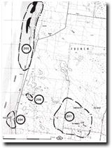 Site 205 to 207, North of Tankerton |

© State of Victoria (Agriculture Victoria) 1996 - .

This work, Victorian Resources Online, is licensed under a Creative Commons Attribution 4.0 licence. You are free to re-use the work under that licence, on the condition that you credit the State of Victoria (Agriculture Victoria) as author, indicate if changes were made and comply with the other licence terms.
The licence does not apply to ‘branding’ or some ‘images or photographs’ that may be owned by third parties. We ask you to seek prior approval to use images using the VRO feedback form. Access to higher quality images can also be provided on request.
This page was last updated on .