
202. North Coast of French Island
|
This information has been developed from one or more of these publications:
|
Location: | Barrallier - 500585 to Palmer - 620590. Mangrove and salt marsh fringe of the northern coastline of French Island between River Point and The Duck Splash. | 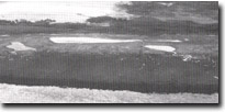 Lagoons, tidal channels, mangrove and fringe at The Duck Splash, Site 202. |
Access: | Coast Road, Bullock Road, The Causeway. | |
Ownership: | Crown land. | |
Geology/Geomorphology: | The northern shoreline of French Island exhibit’s a well developed mangrove-fringed salt marsh in front of a formerly sandy shoreline. The vegetation community of the salt marsh displays high species diversity and is considered to be a focus of botanical importance in Westernport Bay (Bridgewater, 1975). Numerous tidal channels have developed across the salt marsh, and in low lying areas several shallow lagoons have formed. The lagoons are best developed in the Salicornia community at the rear of the salt marsh, with tidal channels meandering through the mangrove fringe and the Arthrocnemum communities at the front of the salt marsh. The most prominent and best developed of these groups of tidal lagoons occurs at ‘The Duck Splash’ west of Palmer Point. The mangrove fringe in the north-west of French Island (Scrub Point) is rapidly dying back under the influence of a rapid and recent influx of sand which is forming beaches and sand cheniers. | |
Significance: | State. The area includes one of the main mangrove and salt marsh resources of Victoria and is a major site to study the sedimentary processes of such a system. | |
Management: | Class 1. No disturbance to the mangrove fringe should be permitted. Cutting of the mangrove, clearing or degrading of channels through the mangrove fringe, or filling or reclamation of any area of the site should not be permitted. | |
References: | Bridgewater, P.B. (1975). Peripheral vegetation of Westernport Bay. Proc. Roy. Soc. Vict. 87 (1) 69-78. | |
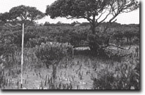 Vigorous growth of mangrove near The Duck Splash, Site 202. |

© State of Victoria (Agriculture Victoria) 1996 - .

This work, Victorian Resources Online, is licensed under a Creative Commons Attribution 4.0 licence. You are free to re-use the work under that licence, on the condition that you credit the State of Victoria (Agriculture Victoria) as author, indicate if changes were made and comply with the other licence terms.
The licence does not apply to ‘branding’ or some ‘images or photographs’ that may be owned by third parties. We ask you to seek prior approval to use images using the VRO feedback form. Access to higher quality images can also be provided on request.
This page was last updated on .