
111. Lang Lang - Earth Cliffs
|
This information has been developed from one or more of these publications:
|
| Location: | Lang Lang - 710610 to Palmer - 678653. Three kilometres north of Lang Lang Beach. | 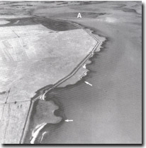 Crenulate coastline with double earth cliff north of Lang Lang River mouth and delta (A). The lower cliff is the darker line (arrowed). Shelly beaches occupy some of the embayments. |
Access: | Walk from Lang Lang Beach or McDonalds Road. | |
Ownership: | Private land and Crown Land. | |
Geology/Geomorphology: | The coastline north of the Lang Lang River mouth is a low cliff varying from 0.2 to 2.0 metres high. In detail, both the plan and the profile of the cliffs are complex and there are numerous small embayments giving an overall crenulate appearance to this coastal sector. This form maybe inherited from the pattern that existed prior to the draining of the Tobin Yallock Swamp and it is currently being smoothed and simplified by wave action. The cliffs are higher on the headlands and provide a clear profile of the sediments that comprise the now drained swamp. Profiles that expose the peaty horizons of the swamp are exposed in the drains forming the Lang Lang River mouth. Detailed analysis of the form and composition of the cliffs is provided by Gell (1974) and miles (1976) who also discusses the age and origin of the swamp materials. Most of the embayments have beaches of coarse shell fragments, sand and minor gravels, and in places these materials have been swept over the cliff top by storm waves to form sandy cheniers. A new delta similar in the form to that at the mouth of the Bunyip River (Site 90) is developing at the Lang Lang River Mouth. | |
Significance: | State. The site includes a coastal form different from that in other parts of Western Port, and is a classic example of a rapidly changing low coastal earth cliff. The exposures of the swamp materials in the cliffs are the best in the Westernport region. | |
Management: | Class 2. Extension of seal walls and artificial embankments, development of coastal facilities or other construction works, and dumping of waste materials that would obscure the cliffed profile north of the Lang Lang River mouth to the Twenty Foot Drain should not be permitted. Repairs to existing embankments could be permitted. Collection and removal of sea grass and shell material from this coast should not be permitted until a study of the impact of removal of this material on coastal erosion is carried out. | |
References: | Gell, R.A. , 1974. Shore development in the Lang Lang area. B.Sc Hons. thesis (unpub). Dept. of Geog., Univ. of Melb. | |
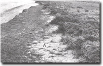 Cliff cut in salt marsh peat and swamp deposits. Stripped zone at cliff top is due to high tide storm waves which also emplace the sand and shell chenier. | 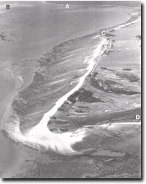 The multiple recurving spits that comprise Stockyard point. Also shown are Lang Lang delta (A), tidal watershed (B), Red bluff (C), part of Pioneer Bay (D). |

© State of Victoria (Agriculture Victoria) 1996 - .

This work, Victorian Resources Online, is licensed under a Creative Commons Attribution 4.0 licence. You are free to re-use the work under that licence, on the condition that you credit the State of Victoria (Agriculture Victoria) as author, indicate if changes were made and comply with the other licence terms.
The licence does not apply to ‘branding’ or some ‘images or photographs’ that may be owned by third parties. We ask you to seek prior approval to use images using the VRO feedback form. Access to higher quality images can also be provided on request.
This page was last updated on .