
100. Heath Hill - Lang Lang River Incision
|
This information has been developed from one or more of these publications:
|
| Location: | Catani - 860663. Lang Lang River floodplain at Heath Hill. | 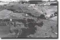 Former channel of Lang Lang River at Heath Hill (A), and diversion channel (B). |
Access: | Western Port road. | |
Ownership: | Crown Land (Public Land Water Frontage Reserve), and private land. | |
Geology: | Exposed in the deeply incised channel of the Lang Lang River are silty sands and clays with occasional pebble layers. Wood fragments and coalified logs are common towards the bottom of the sequence (Thompson, 1974). Thompson (1970) referred to this sequence as the Heath Hill Silts, and regarded them as of fluvial origin and post-dating the main movement of the Heath Hill Fault. Near Western Port Road bridge, river incision had reached the base of the Heath Hill Silts and exposed basalts of the Older Volcanics. | |
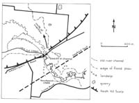
Geomorphology: | Below the road bridge, the Lang Lang River follows an artificial alignment. It occupies a trench which is now deeply incised below the level of the former flood plain and adjacent drained swamplands. The area has a long history of drainage, reclamation, and flood control schemes, and the related phase of deep and rapid channel incision has been related to changes in stream gradient and discharge subsequent to those schemes. The site includes an abandoned course and floodway of the Lang Lang River immediately downstream from the bridge, and a sector of the New cut (a diversion drain cut in 1926 to shorten and straighten the river course). The temporary base level of stream downcutting is formed by outcrops of Older Volcanics basalt which are exposed at the Western Port Road bridge. | |
Significance: | National. The area is a classic site to demonstrate the rapid geomorphological changes that may accompany engineering works on river systems. The present phase of rapid incision and retreat of the knickpoint in the channel have been clearly documented and related to the drainage and other river control schemes implemented since the 1870's. It provides a major opportunity to study rapid river channel change and the impact of engineering works on landforms and geomorphological processes. | |
Management: | Class 1. The nature of future management of the site will need to be continually reassessed in the light of hazards created by the extension of channel erosion. It is very important that any future control or engineering works are preceded by detailed recording (by maps and photographs) of the characteristics of the site. This particularly applies to the nature of the channel cross section, the position of the knickpoint, and the composition of the channel floor materials. It is recommended that the abandoned channel section below the road bridge be left in its present configuration to serve as an indication of the dimensions of the channel before drainage programmes were implemented. Any construction or excavation activities that would obscure this section should be prohibited. | |
References: | Key, L. M. , 1967. Historical geography of the Kooweerup District. M.A. thesis (unpub.) Dept. of Geog. Univ. of Melb. Thompson, B. R. ,1974. The geology and hydrology of the Western Port sunklands. Geol. Surv. Rept. 1974/1 Thompson (1970). Bird, J. F. , 1981. Geomorphological implication of flood control measures, Lang Lang River, Victoria. Aust. Geog. Stud. 169-183. | |
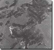 Deeply incised rejuvenated channel of Lang Lang River upstream from Heath Hill bridge. |

© State of Victoria (Agriculture Victoria) 1996 - .

This work, Victorian Resources Online, is licensed under a Creative Commons Attribution 4.0 licence. You are free to re-use the work under that licence, on the condition that you credit the State of Victoria (Agriculture Victoria) as author, indicate if changes were made and comply with the other licence terms.
The licence does not apply to ‘branding’ or some ‘images or photographs’ that may be owned by third parties. We ask you to seek prior approval to use images using the VRO feedback form. Access to higher quality images can also be provided on request.
This page was last updated on .