
LP116
| Group: Bendigo Creek Floodplain Group | Australian Soil Classification: Episodic-Endocalcareous, Epipedal, Brown VERTOSOL |
| Northcote Factual Key:Ug 5 | Great Soil Group: brown clay |
| General Site Description: Level plain. | Geology: Alluvial deposits. (Quaternary). Coonambidgal Formation. |
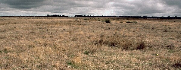 LP116 Landscape |
Soil Profile Morphology
Surface Soil
| A1 | 0-5 cm | Dark brown (10YR4/3), light medium clay; strong coarse blocky structure; firm consistence when moderately moist; rusty root channel mottles evident; pH 6.1; abrupt change to: | 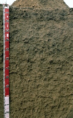 LP Profile |
| A2 | 5-12 cm | Dark yellowish brown (10YR4/4), medium clay; strong coarse blocky structure breaking to strong medium sized blocky structure; weak consistence when moderately moist; few (10%) manganese stains; pH 6.4; clear change to: | |
| Subsoil | |||
| B21 | 12-50 cm | Yellowish brown (10YR5/4), medium heavy clay; moderate coarse blocky structure, breaking to moderate fine blocky structure; firm consistence when moderately moist; few manganese stains; pH 7.1; slickensides evident from 30 cm; gradual change to: | |
| B22 | 50-80 cm | Yellowish brown (10YR5/6 & 10YR5/4), medium heavy clay; weak coarse polyhedral structure, breaking to moderate medium sized polyhedral structure; firm consistence when moist; few (2%) hard carbonate nodules; pH 8.2; gradual change to | |
| B23 | 80-130 cm | Yellowish brown (10YR5/6) with strong brown (7.5YR5/6) mottle, light medium clay; strong medium sized polyhedral structure; weak consistence when moist; few manganese stains; pH 8.6. | |
Key Profile Features
- The entire profile is consistently at least a light medium clay.
- Vertic properties: surface cracks and slickensides evident from 30 cm.
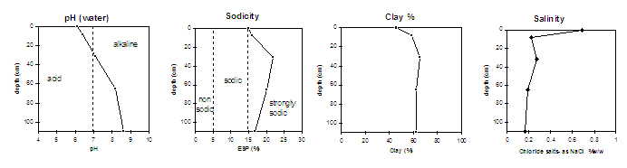
Key Profile Characteristics
pH | Salinity Rating | |||
Surface (A1 horizon) | slightly acid | high | strongly sodic | none1 |
Subsoil (B21 horizon) | slightly alkaline | moderate | strongly sodic | none1 |
Deeper subsoil (at 80-110 cm) | strongly alkaline | moderate | strongly sodic | slight dispersion |
| 1 Probably due to the high level of soluble salt. | ||||
 |
Management Considerations:
Whole Profile
- The entire profile is at least moderately saline with the highest level of salt at the surface. This may be related to the close proximity to the dam and may not be representative of the whole paddock. These levels of soluble salts are likely to affect growth of a number of plant species.
- The entire profile is sodic but is not strongly dispersive due to the high salt content of the soil. Root and water movement may be restricted in the deeper subsoil. Water is likely to build up on the surface after heavy rains causing waterlogging and surface runoff.
- This profile is clayey throughout. This type of soil with a high wilting point will require more rainfall than lighter textured soils before moisture is available for plant uptake.
Surface (A) Horizons
- Tillage of cracking clay soils should be avoided if the soil is wet (ie. wetter than the plastic limit). At such moisture conditions, tillage or excessive trafficking or overstocking could result in structural damage (eg. compaction, smearing) occurring. Ideally, tillage and trafficking should take place on cracking clay soils when the soil is drier than the plastic limit, down to at least the tillage depth.
Subsoil (B) Horizons
- The deeper subsoil (from 60 cm depth) is strongly alkaline which indicates that some nutrients (e.g. copper, iron, manganese, and zinc) may be poorly available to deeper rooted plants.
- The subsoil displays vertic properties (ie. slickensides) which indicates that significant shrinking and swelling occurs in the deeper subsoil. This may have implications for engineering purposes (eg. disturbance to fencelines).
Notes
- Profile described by Paul Rampant and Ruth Lourey (22/5/96)
© State of Victoria (Agriculture Victoria) 1996 - .

This work, Victorian Resources Online, is licensed under a Creative Commons Attribution 4.0 licence. You are free to re-use the work under that licence, on the condition that you credit the State of Victoria (Agriculture Victoria) as author, indicate if changes were made and comply with the other licence terms.
The licence does not apply to ‘branding’ or some ‘images or photographs’ that may be owned by third parties. We ask you to seek prior approval to use images using the VRO feedback form. Access to higher quality images can also be provided on request.
This page was last updated on .