
Rudosols
Rudosols are soils with negligible (rudimentary) pedological development, apart from minimal development of a surface (A) horizon.
Three types of Rudosol can be found in the North East region:
- Stratic Rudosols - These are soils where at least the upper 50 cm of the soil profile mainly consists of unconsolidated mineral materials that are distinct sedimentary layers but are not (or only slightly) gravelly.
- Clastic Rudosols - These are soils where at least the upper 50 cm of the soil profile mainly consists of mineral materials that are gravelly i.e. more than 10% of the material is greater than 2 mm in size. The gravel may be in distinct layers, or uniformly or irregularly distributed.
- Leptic Rudosols - These are soils that within 50 cm of the surface there is hard unweathered rock, other hard materials, or partially weathered or decomposed saprolite.
Note that other soil types may also occur within these mapped areas either dominantly or sub-dominantly, depending on factors such as climate, landform, geology, vegetation and degree of weathering. This map will continue to be updated as new information becomes available. Access the Soil and Land Survey Directory from this website, to find out more detailed information from various soil and land surveys that cover parts of this region. |
| Stratic Rudosols Previously referred to as:
Variable soils dependant on the parent material source and the position in the depositional regime of the stream. Where the surface texture is fine and the site is moist for long periods, the accumulation of organic matter will produce a dark well-structured surface (A) horizon. There is usually little variation in texture or colour below the surface horizon, and gravel often occurs within one metre of the soil surface. The soils on drier ephemeral-stream deposits and alluvial fans usually have only minimal organic darkening of the surface horizon. The soils are typically acid throughout and plant nutrient availability is quite variable, possibly influenced by the degree of weathering of the sediments from which they are formed. They may have good infiltration capacity but probably low water holding capacity. | 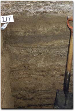 Example of a Stratic Rudosol in the North East region. |
Leptic Rudosols
Previously referred to as:
- Lithosols, undifferentiated stony loams, stony loam soils.
- In the North East region, these soils are most common in the sub-alpine zone. They also occur in the drier northern areas where the landscape is hilly to steep, within the upper slopes and ridge tops. Leptic Rudosols are found in situations where long-term slope instability or exposure to severe erosion, results in minimal deep weathering and continuous removal of fine material.
Generalised Description:
Leptic Rudosols are shallow soils containing large amounts of rock fragments. The soil material is usually coarse textured with a very low clay content and minimal organic matter accumulation at the surface. The soils are strongly acid and have a low water holding capacity due to the coarse texture, abundant stones and shallow depth. However, infiltration rates can be high.
Clastic Rudosols
Previously referred to as:
- Gravelly loam soils, weakly bleached yellowish brown Gradational soil.
- Formed in deep alluvial/colluvial deposits, usually in fan formations at base of steep slopes.
Two forms of these soils have been described in the North East region.
- The gravelly loam soils (Rowe 1984) are formed in deep alluvial/colluvial deposits, usually in fan formations at the base of steep slopes.
- The other form consists predominantly of slope mantles that are not usually very deep and may overlie remnants of older soil or saprolite, referred to as weakly bleached yellowish brown Gradational soils.
The gravel content of both types may be up to 40%. They are strongly acid throughout (pH less than 5.5) and apart from the darkening of the surface horizon by organic-matter accumulation, they display little or no pedogenic organisation. The texture profile can be variable.
Reference
Rowe, R.K (1967). A Study of the Land in the Victorian Catchment of Lake Hume. Soil Conservation Authority. Victoria. Technical Communication 5.
Rowe, R.K (1984). A Study of the Land in the Catchments of the Upper Ovens and King Rivers. Soil Conservation Authority. Victoria. Technical Communication 16.
Rowe, R.K (1972). A Study of the Land in the Catchment of the Kiewa River. Soil Conservation Authority. Victoria. Technical Communication 8.
© State of Victoria (Agriculture Victoria) 1996 - .

This work, Victorian Resources Online, is licensed under a Creative Commons Attribution 4.0 licence. You are free to re-use the work under that licence, on the condition that you credit the State of Victoria (Agriculture Victoria) as author, indicate if changes were made and comply with the other licence terms.
The licence does not apply to ‘branding’ or some ‘images or photographs’ that may be owned by third parties. We ask you to seek prior approval to use images using the VRO feedback form. Access to higher quality images can also be provided on request.
This page was last updated on .