
NE48
Soil Profile Morphology: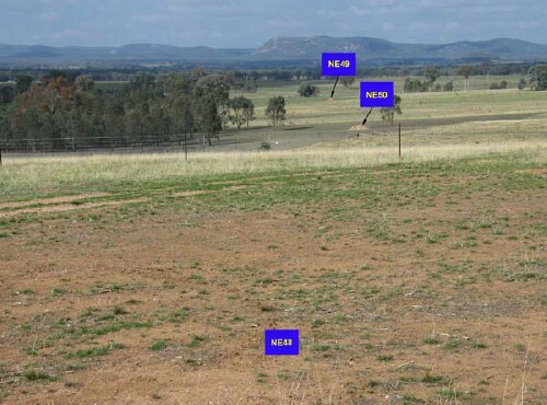
NE48-50 Landscape
Surface Soil
| A1 | 0-10 cm | Dark brown (7.5YR3/3); sandy loam; weak to moderate coarse to medium blocky structure; firm consistence (dry); very abundant (50-90%) medium quartz rock (5-30 mm); no slaking; pH 4.4; clear change to: | 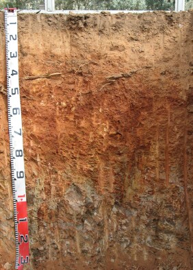 NE48 Profile |
| A2 | 10-23 cm | Yellowish red (5YR5/6) and pink (7.5YR7/4 dry); sandy loam; weak coarse blocky structure; very firm (dry) consistence; very abundant (50-90%) quartz rock (5-30 mm); pH 4.6; very slight dispersion after remoulding: | |
| Subsoil | |||
| B21 | 23-50 cm | Red (2.5YR5/6); light medium clay; strong coarse to fine polyhedral structure; strong consistence (dry); pH 4.8: | |
| B/C | 50-80 cm | Red (2.5YR4/6); silty clay loam; termites; pH 5: | |
| C | 80 cm | Weathered metamorphic??? rock; slight dispersion after remoulding. | |
| Note: Quartz band from 40 cm. | |||
Key Profile Features:
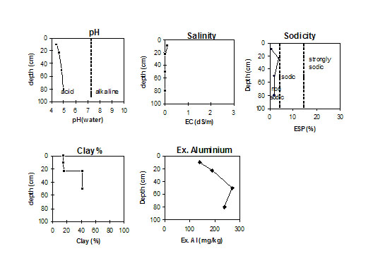
Soil Profile Characteristics:
Horizon | pH | Salinity Rating | ||
Surface (A1 horizon) | Extremely Acid | |||
Subsoil (B2 horizon) | Very Strongly Acid | |||
Deeper subsoil (at 50-80 cm cm) | Strongly Acid |
Horizon | Horizon Depth (cm) | pH (water) | pH (CaCl2) | EC 1:5 | Organic Carbon G/100g | Exchangeable Cations | |||
Ca | Mg | K | Na | ||||||
meq/100g | |||||||||
A1 | 0-10 | 4.4 | 4.0 | 0.09 | 3.4 | 0.97 | 0.41 | 0.88 | 0.12 |
A2 | 10-23 | 4.6 | 4.2 | <0.05 | 0.24 | 0.37 | 0.29 | <0.05 | |
B21 | 23-50 | 4.8 | 4.1 | <0.05 | 0.24 | 1.9 | 0.46 | <0.05 | |
B/C | 50-80 | 5 | 4.2 | <0.05 | 0.08 | 1.7 | 0.41 | <0.05 | |
C | 80 | ||||||||
Horizon | Horizon Depth (cm) | Exchangeable Aluminium mg/kg | Exchangeable Acidity meq/100g | Field Capacity pF 2.5 | Wilting Point pF 4.2 | Coarse Sand (0.2-2.0 mm) | Fine Sand (0.02-0.2 mm) | Silt (0.002-0.02 mm) | Clay (<0.002 mm) |
A1 | 0-10 | 140 | 12 | 23.0 | 6.9 | 19 | 48 | 10 | 15 |
A2 | 10-23 | 190 | 6.8 | 19.1 | 6.6 | 18 | 51 | 12 | 16 |
B21 | 23-50 | 270 | 9.8 | 27.0 | 15.6 | 11 | 33 | 10 | 42 |
B/C | 50-80 | 240 | 8.4 | 27.2 | 13.7 | ||||
C | 80 |
© State of Victoria (Agriculture Victoria) 1996 - .

This work, Victorian Resources Online, is licensed under a Creative Commons Attribution 4.0 licence. You are free to re-use the work under that licence, on the condition that you credit the State of Victoria (Agriculture Victoria) as author, indicate if changes were made and comply with the other licence terms.
The licence does not apply to ‘branding’ or some ‘images or photographs’ that may be owned by third parties. We ask you to seek prior approval to use images using the VRO feedback form. Access to higher quality images can also be provided on request.
This page was last updated on .