
NE40
| Property: Rutherglen Research Institute | Paddock #: 30 |
| Aust. Soil Class.: Haplic, Eutrophic, Red CHROMOSOL (gravelly surface) | Northcote Factual Key: Dr 2.42 |
| Great Soil Group: no suitable group | Map Unit: Type H |
| General Landscape Description: Upper slope of hill (3% slope). (Ordovician sediments). | |
Soil Profile Morphology:
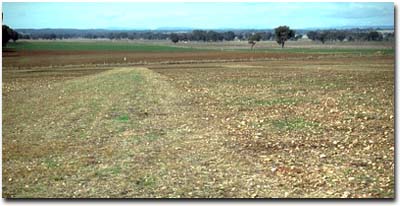
NE40 Landscape
Surface Soil
| A1 | 0-15 cm | Dark reddish brown (5YR3/3); sandy clay loam; weak consistence moist; contains many (50%) quartz gravel fragments (4-40 mm size); pH 5.5; abrupt change to: | 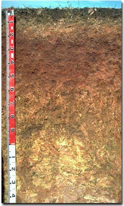 NE40 Profile |
| A2 | 15-20 cm | Yellowish red (5YR4/8); fine sandy clay loam; discontinuous; contains an abundant (70%) amount of quartz gravel (4-50 mm size); abrupt change to: | |
| Subsoil | |||
| B21 | 20-45 cm | Red (10R4/8); medium heavy clay; strong coarse blocky, breaking to strong fine polyhedral structure; firm consistence moderately moist; contains a trace (< 2%) amount of quartz gravel (2 - 5 mm size); pH 6.2; gradual change to: | |
| B22 | 45-70 cm | Dark red (2.5YR4/8) with strong brown (7.5YR5/8) mottles; medium clay; strong coarse blocky, breaking to strong fine polyhedral structure; very firm consistence moderately moist; contains a few (2%) quartz gravel fragments (5-20 mm size); pH 6.9; | |
| B23 | 70-100 cm | Dark red (10R3/6) with yellowish brown (10YR5/8) mottles; medium clay; moderate very coarse prismatic, breaking to moderate coarse blocky structure; very firm consistence moderately moist; contains a few (2%) quartz gravel fragments; pH 7.3; | |
| B3 | 100-130 cm | Yellow (10YR7/6) with dark red (2.5YR4/8) mottles; light clay; moderate coarse prismatic, breaking to moderate coarse blocky to fine blocky structure; firm consistence moderately moist; contains many (50%) weathered rock fragments; pH 7.7. | |
| C | 130+ cm | Mudstone. | |
Key Profile Features:
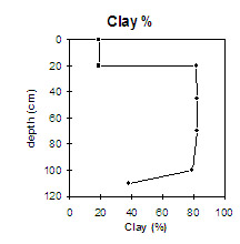
- Strong texture contrast between surface (A) horizons (18% clay) and subsoil (B21) horizon (82 % clay).
- Gravelly surface horizons.
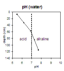 | The surface horizons are strongly acid. The upper subsoil is slightly acid and the deeper subsoil is slightly alkaline. | 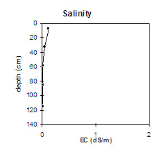 | The salinity rating is very low throughout. |
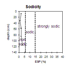
| The soil profile is non-sodic throughout. |
| There is a significant increase in clay percentage at the A/B horizon interface. |
Management Considerations:
Whole Profile
- Plant available water capacity (PAWC) is considered to be medium (estimated at 110 mm) for the top metre of the soil profile. This is based on available laboratory data. Most roots were evident in the top 50 cm of the profile (which has an estimated PAWC of approx. 50 mm).
- The level of exchangeable aluminium is low (10 mg/kg) in the strongly acid surface soil. These levels are not likely to affect plant growth. However, a pH/aluminium test on a bulked sample (taken from across the paddock) would be most appropriate to determine if lime is needed to raise soil pH.
- The large amount of coarse gravel will be abrasive to farm implements.
- The subsoil is non-sodic and strongly structured (breaking to fine polyhedral shaped peds). This will provide suitable conditions for root and water movement. The reddish colour and lack of mottling in the upper subsoil indicates that drainage and aeration is good.
- The subsoil has a moderate nutrient status (based on the sum of the exchangeable basic cations).
- Cultivated old grapevine area (1984)
- Disc cultivated (1986), Cultivated (1987).
- Experimental plots (peas), 1994.
- Sub. clover sown in 1996.
© State of Victoria (Agriculture Victoria) 1996 - .

This work, Victorian Resources Online, is licensed under a Creative Commons Attribution 4.0 licence. You are free to re-use the work under that licence, on the condition that you credit the State of Victoria (Agriculture Victoria) as author, indicate if changes were made and comply with the other licence terms.
The licence does not apply to ‘branding’ or some ‘images or photographs’ that may be owned by third parties. We ask you to seek prior approval to use images using the VRO feedback form. Access to higher quality images can also be provided on request.
This page was last updated on .