
NE4
| Property: Rutherglen Research Institute | Paddock #: 18 |
| Australian Soil Classification: Ferric (and Calcic), Mottled-Subnatric, Brown SODOSOL | Northcote Factual Key: Dy 2.43 |
| Great Soil Group: Solodic | |
| Map Unit: Unit II. The soil at this site most closely resembles Lilliput loam which occurs in depression components of the unit. | |
| General Landscape Description: Level plain. The original vegetation included Yellow Box (Eucalyptus melliodora) and Blakely's Red Gum (E. blakelyi). | |
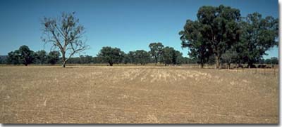 NE4 landscape |
Soil Profile Morphology:
Surface Soil
| A1 | 0-5 cm | Brown (10YR4/3); light fine sandy clay loam; hardsetting surface condition; massive; firm consistence dry; contains a slight (5%) amount of quartz gravel (2-5 mm); pH 5.2; sharp and wavy change to: | 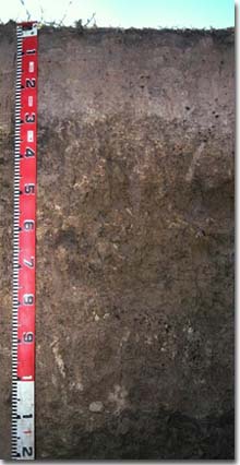 NE4 profile |
| A2 | 5-30 cm | Reddish yellow (7.5YR6/6) conspicuously bleached (10YR8/2d); light fine sandy clay loam; massive; strong consistence dry; contains very many (80%) ferromanganiferous nodules; pH 6.2; abrupt change to: | |
| Subsoil | |||
| B21 | 30-40 cm | Yellowish brown (10YR5/4); light medium clay; moderate medium polyhedral structure; very strong consistence moist; contains a common (10-20%) amount of ferromanganiferous stains and concretions as well as a trace (2%) amount of quartz gravel (2-4 mm size); pH 6.3; clear and discontinuous change to: | |
| B22 | 40-80 cm | Yellowish brown (10YR5/4) with brownish yellow (10YR6/8) diffuse mottles; medium clay; moderate coarse blocky structure; rigid consistence moist; contains a common (20%) amount of ferromanganiferous stains and gravels as well as a trace (2%) amount of quartz gravel; pH 7.2; gradual and wavy change to: | |
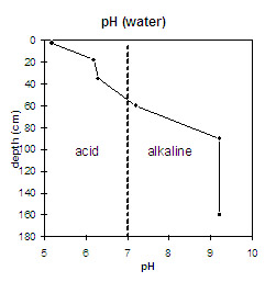
| B23k | 80-100 cm | Yellowish brown (10YR5/4) with brownish yellow (10YR6/8) [with patches of yellowish brown (5YR5/6)] mottles; light medium clay; moderate coarse blocky structure; very strong consistence moist; contains a few (5%) soft carbonate segregations, as well as a trace (2%) amount of quartz gravel; pH 9.2; gradual change to: | |
| B24 | 100-150+ cm | Yellowish brown (10YR5/4) and brownish yellow (10YR6/8); light medium clay; pH 9.2. | |
Key Profile Features:
- Strong texture contrast between surface (A) horizons (< 20% clay) and subsoil (B21) horizon (46% clay)
- Conspicuously bleached A2 horizon.
- Contains a large amount of ferromanganiferous nodules in the subsurface (A2) horizon.
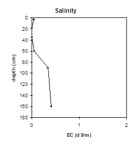
 |
|  |
|
|
|
|
|

Management Considerations:
Surface (A) Horizons
- The hardsetting surface soil has a high fine sand and silt content (ie. 68 %). Organic matter is therefore very important for maintaining surface soil aggregation and preventing slaking. Organic matter levels will build up under pasture but will decline if cultivation takes place. Practices such as residue retention, minimum tillage and including pasture rotations should be utilised if cropping occurs. Improving organic matter levels will also enhance soil fertility and water holding capacity.
- The presence of a conspicuously bleached subsurface (A2) horizon with a large amount of ferromanganiferous nodules indicates that waterlogging occurs at this site as water builds up on top of the slowly permeable subsoil. This horizon will become 'spewy' as a result.
- The level of exchangeable aluminium (83 ug/g) measured for this horizon may only restrict the growth of highly aluminium sensitive species.
- The surface horizons have a very low nutrient status (based on the sum of the exchangeable basic cations). Increasing organic matter levels will assist in enhancing soil fertility as well as water holding capacity.
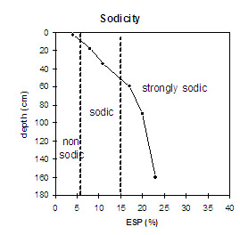
- The dense and coarsely structured subsoil is sodic (as well as having a low calcium:magnesium ratio) and dispersive. Plant root and water movement will be restricted as a result. Water will build up on top of the poorly permeable subsoil and waterlogging will occur after heavy rains.
- The large amount of manganese segregations in the subsoil may have a toxic effect on deeper rooted manganese sensitive species.
© State of Victoria (Agriculture Victoria) 1996 - 2025.

This work, Victorian Resources Online, is licensed under a Creative Commons Attribution 4.0 licence. You are free to re-use the work under that licence, on the condition that you credit the State of Victoria (Agriculture Victoria) as author, indicate if changes were made and comply with the other licence terms.
The licence does not apply to ‘branding’ or some ‘images or photographs’ that may be owned by third parties. We ask you to seek prior approval to use images using the VRO feedback form. Access to higher quality images can also be provided on request.
This page was last updated on 25/01/2019.