
NE37a
| Property: Rutherglen Research Institute | Paddock #: PTD 2 (native grass) |
| Aust. Soil Class.: Vertic (and Hypocalcic), Mottled-Subnatric, Grey SODOSOL | Northcote Factual Key: Dy 3.43 |
| Great Soil Group: solodic | |
| Map Unit: Unit 2 (a gilgai complex of four soil types: Rutherglen loam (deep and normal phases), Lilliput loam, and Types D and E). | |
| General Landscape Description: This site occurs in a paddock which has never been cultivated. Well developed gilgai microrelief is present. This soil occurs on the edge of the depression component of the gilgai microrelief and is similar to Lilliput loam [as described by Poutsma and Skene (1961)]. Wallaby Grass (Danthonia sp) commonly grows in the gilgai hollows. | |
Soil Profile Morphology:
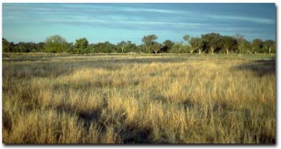
NE37a Landscape
Surface Soil
| A1 | 0-20 cm | Brown (10YR4/3); fine sandy clay loam; firm consistence dry; rusty root channel mottling present; pH 5.8; abrupt change to: | 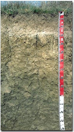 NE37a Profile |
| A2 | 20-25 cm | Very pale brown (10YR7/3) conspicuously bleached; fine sandy clay loam; contains a few (5%) ferruginous and manganiferous nodules (5-10 mm size); pH 6.6; sharp change to: | |
| Subsoil | |||
| B21 | 25-70 cm | Light brownish grey (10YR6/2) with yellowish brown (10YR5/8) mottles; heavy clay; deep cracks evident; moderate very coarse prismatic structure (slickensides present at 50 cm); bleached material from above present along ped faces; rigid consistence dry; pH 6.7; gradual change to: | |
| B22 | 70-110 cm | Light olive brown (2.5Y6/4) heavy clay; coarsely structured; large slickensides present; contains very few (2%) ferromanganiferous nodules; clear change to: | |
| B23 | 110-140 cm | Light olive brown (2.5Y5/4); heavy clay; slickensides present; contains a trace (< 2%) amount of carbonate-silica nodules (2-10 mm size) and a few (5-10%) ferromanganiferous nodules (2-5 mm size), slickensides present; pH 8.8. | |
Key Profile Features:
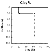
- Strong texture contrast between surface (A) horizons (< 26% clay) and sodic subsoil (B21) horizon (62% clay). (ie. SODOSOL)
- Vertic properties in deeper subsoil.
- Conspicuously bleached subsurface (A2) horizon.
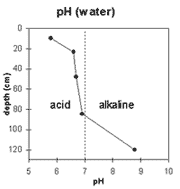 | The surface soil is moderately acid. The upper subsoil is slightly acid and the deeper subsoil is strongly alkaline. | 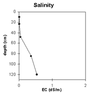 | The salinity rating is very low throughout the upper metre of the soil profile. It becomes low-medium below 1 metre depth. |
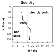
| The upper subsoil is sodic. The deeper subsoil is strongly sodic. Strong to complete dispersion occurs throughout the subsoil. |
| The clay % increases significantly at the A/B horizon interface. |
Management Considerations:
Whole Profile
- Plant Available Water Capacity (PAWC) is considered to be low for this profile. Effective rooting depth will be restricted by the sodic and strongly dispersive dense subsoil. Available water for the surface (A1) horizon is estimated at 30 mm.
- The rusty root channel mottling in the surface horizon indicates that periodic waterlogging occurs due to the slowly permeable subsoil.
- The surface soil has a high fine sand and silt content (65%). Organic matter is therefore important for maintaining aggregation and preventing slaking.
- The surface soil has a low nutrient status (based on the sum of the exchangeable basic cations).
- The dense and coarsely structured subsoil is sodic and disperses completely. This will result in significant restriction to root and water movement in the subsoil.
- The deeper subsoil exhibits vertic properties (ie. significant cracking, presence of slickensides) which indicates that significant shrinking and swelling occurs in wetting and drying cycles. This will cause subsoil movement and has resulted in the formation of gilgai ("crabholey") microrelief at the surface.
- Never cultivated.
© State of Victoria (Agriculture Victoria) 1996 - .

This work, Victorian Resources Online, is licensed under a Creative Commons Attribution 4.0 licence. You are free to re-use the work under that licence, on the condition that you credit the State of Victoria (Agriculture Victoria) as author, indicate if changes were made and comply with the other licence terms.
The licence does not apply to ‘branding’ or some ‘images or photographs’ that may be owned by third parties. We ask you to seek prior approval to use images using the VRO feedback form. Access to higher quality images can also be provided on request.
This page was last updated on .